BDR Route GPX Support
-
I was having trouble uploading the GPX file for the Southest BDR so I came to the forum to search for other posts on the topic. It looks like the last time this was addressed was almost 4 years ago. BDR routes are gaining in popularity significantly more every year. It would be a real shame to have to spend hours fixing an import that should be pretty straight forward. The GPX files work perfect in both Osmand and OnX. I haven't tried any other nav apps yet. While routes are awesome for onroad riding, the vast majority of offroad navigation is still via tracks, at least here in the US.
Is there anything on the roadmap to improve the import functionality? I love MRA but find that migrating everything over has been painful. I will probably have to stick with OnX or Osmand for BDR routes which is a shame.
You can see here the track imports but none of the waypoints.
https://www.myrouteapp.com/en/social/track/883802?mode=share -
I was having trouble uploading the GPX file for the Southest BDR so I came to the forum to search for other posts on the topic. It looks like the last time this was addressed was almost 4 years ago. BDR routes are gaining in popularity significantly more every year. It would be a real shame to have to spend hours fixing an import that should be pretty straight forward. The GPX files work perfect in both Osmand and OnX. I haven't tried any other nav apps yet. While routes are awesome for onroad riding, the vast majority of offroad navigation is still via tracks, at least here in the US.
Is there anything on the roadmap to improve the import functionality? I love MRA but find that migrating everything over has been painful. I will probably have to stick with OnX or Osmand for BDR routes which is a shame.
You can see here the track imports but none of the waypoints.
https://www.myrouteapp.com/en/social/track/883802?mode=share@Kerry-Lebel if you import a track in MRA it will never have waypoints
If you share the gpx file I will try to help you out -
For those who are not familiar with 'BDR'. It means Backcountry Discovery Route.
-
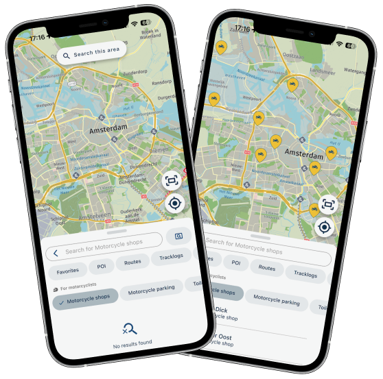
This is still an issue. If we can figure out a way to address this is would be great. BDR's are extremely popular in the US. The GPX files that the organization provides has tracks and POI data for interesting stops and view points along the way. When you import the GPX file, it will convert the tracks into 'Route-Track' and the POI data is not imported. Any thoughts on how to address this would be great. I tried to to attach the file but got a message I don't have the privileges.
-
This is still an issue. If we can figure out a way to address this is would be great. BDR's are extremely popular in the US. The GPX files that the organization provides has tracks and POI data for interesting stops and view points along the way. When you import the GPX file, it will convert the tracks into 'Route-Track' and the POI data is not imported. Any thoughts on how to address this would be great. I tried to to attach the file but got a message I don't have the privileges.
@Kerry-Lebel attachments require reputation points, have an up vote to help you along
-
This is still an issue. If we can figure out a way to address this is would be great. BDR's are extremely popular in the US. The GPX files that the organization provides has tracks and POI data for interesting stops and view points along the way. When you import the GPX file, it will convert the tracks into 'Route-Track' and the POI data is not imported. Any thoughts on how to address this would be great. I tried to to attach the file but got a message I don't have the privileges.
@Kerry-Lebel said in BDR Route GPX Support:
...When you import the GPX file, it will convert the tracks into 'Route-Track' and the POI data is not imported...
Yes, that's the current situation in MRA: if a gpx contains a track - and POI - then MRA will only import the track. But not the POI.
It's also common in Europe, to share rides by a track, not by route. Because routes are mostly different after importing in different devices. It's the nature of a track, it has only 2 points visible: the start and the end point. Therefore creators of such tracks includes often POI to support the navigation (p.e. gas stations, restaurants, view points, monuments, check points, etc.)
It's often discussed here by several users, but there is no "official" statement by developers, if they will include it in future...
Nothing is impossible ;-)
In past: GARMIN Zumo 210->GARMIN Zumo 395->GARMIN XT=> now: DMD T865-X + MyRoute-App, LocusMaps, OsmAnd.
In past: GARMIN MapSource ->GARMIN BaseCamp->Tyre->Kurviger->Calimoto=> now: MRA-Routplanner. -
@Kerry-Lebel this is still an issue as @guzzist mentioned.
Send me the file in a PM, I have made a tool to filter waypoints out off GPX files -
This is still an issue. If we can figure out a way to address this is would be great. BDR's are extremely popular in the US. The GPX files that the organization provides has tracks and POI data for interesting stops and view points along the way. When you import the GPX file, it will convert the tracks into 'Route-Track' and the POI data is not imported. Any thoughts on how to address this would be great. I tried to to attach the file but got a message I don't have the privileges.
Hi @Kerry-Lebel not sure if this will fit exactly what your after but it may be a bit of a work around the issue
if you upload the GPX file with the route/track/poi's as normal
you should end up with a route or track of the path you want to follownow in the route file click the 3 hamburger menu next to "Waypoints" to expose the menu & select the POI tab
on the POI tab select "Library" & then "Add"
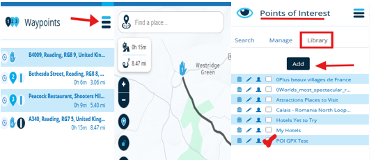
if you select the same GPX file to upload I think this will load the POI's
you just need to place a tick in the selection box for the POI's to always show for this route in MRAit will only be the POI name, no other details, as MRA does not cater for detailed info within POI's
MRA prefers to have detailed info in the Waypoint > Notes field
these POI's will not be exported if you save the route out of MRA as a GPX
they will only be displayed within the -
@Kerry-Lebel said in BDR Route GPX Support:
...When you import the GPX file, it will convert the tracks into 'Route-Track' and the POI data is not imported...
Yes, that's the current situation in MRA: if a gpx contains a track - and POI - then MRA will only import the track. But not the POI.
It's also common in Europe, to share rides by a track, not by route. Because routes are mostly different after importing in different devices. It's the nature of a track, it has only 2 points visible: the start and the end point. Therefore creators of such tracks includes often POI to support the navigation (p.e. gas stations, restaurants, view points, monuments, check points, etc.)
It's often discussed here by several users, but there is no "official" statement by developers, if they will include it in future...
@Guzzist thank you for clearing that up for me. I will hold tight and hopefully this will get updated. MRA is my go to in 70% of my riding but I cant use it at all for BDR trips or any local ADV trips because everyone is sharing tracks with POI data for lockouts, etc. If MRA managed data with collections like OnX, Osmand and Garmin, it would definitely be the only tool I would need.
Hello! It looks like you're interested in this conversation, but you don't have an account yet.
Getting fed up of having to scroll through the same posts each visit? When you register for an account, you'll always come back to exactly where you were before, and choose to be notified of new replies (either via email, or push notification). You'll also be able to save bookmarks and upvote posts to show your appreciation to other community members.
With your input, this post could be even better 💗
Register Login-
71176.5k
-
020500
-
026457
-
0354
-
1215295
-
19569
-
0249
-
091.2k