Suggestion: Enhance and Clarify GPX Export
-

The route planner is excellent. It is easy build a route. Via points and shaping points are clearly identified and it is easy to switch between them. The ability to export the route in various formats is great.
MRA currently has the ability to export a gpx file containing the route, and/or a track generated from the route. Both are useful.
For route export, it offers both the gpx 1.1 variant which includes via and shaing points and the gpx 1.2 variant which includes via points and route point extensions.Enhancement Suggestions:
It would be helpful to have additional options to include:
- via points, shaping points, and route point extensions in the exported route.
- only via points in the exported route.
- gpx waypoints (e.g. <wpt lat="44.006372485309839" lon="-71.242526555433869"> ... </wpt> ) generated from the via and, optionally, shaping points.
Clarifications:
The current gpx export interface has checkboxes to include:
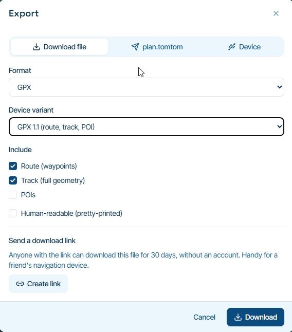
- "Route (waypoints)" but does not actually export any gpx waypoints. (It does export via and shaping points which, outside of gpx, are sometimes reffered to as waypoints.)
- "POIs" but the gpx format does not support POIs (they go in gpi files).
Although the export interface offers the variant "GPX 1.2", it actually writes a gpx 1.1 formatted file (<gpx version="1.1" creator="MyRoute-app" ...) As far as I know, there is no published gpx 1.2 standard.
Interface thought
The export interface under Format GPX might be enhanced to something like (with checkboxes):
-
Export Route containing Via points
--- Also include Shaping points in the Route
--- Also include Route Point Extensions in the Route -
Export Track generated from the Route
-
Export GPX Waypoints generated from the Via points
--- Also export GPX Waypoints generated from the Shaping points
(It would probably make sense to write all gpx Waypoints in route order.)
BTW: The "Human-readable (pretty-printed)" option is very helpful.
-
The route planner is excellent. It is easy build a route. Via points and shaping points are clearly identified and it is easy to switch between them. The ability to export the route in various formats is great.
MRA currently has the ability to export a gpx file containing the route, and/or a track generated from the route. Both are useful.
For route export, it offers both the gpx 1.1 variant which includes via and shaing points and the gpx 1.2 variant which includes via points and route point extensions.Enhancement Suggestions:
It would be helpful to have additional options to include:
- via points, shaping points, and route point extensions in the exported route.
- only via points in the exported route.
- gpx waypoints (e.g. <wpt lat="44.006372485309839" lon="-71.242526555433869"> ... </wpt> ) generated from the via and, optionally, shaping points.
Clarifications:
The current gpx export interface has checkboxes to include:
- "Route (waypoints)" but does not actually export any gpx waypoints. (It does export via and shaping points which, outside of gpx, are sometimes reffered to as waypoints.)
- "POIs" but the gpx format does not support POIs (they go in gpi files).
Although the export interface offers the variant "GPX 1.2", it actually writes a gpx 1.1 formatted file (<gpx version="1.1" creator="MyRoute-app" ...) As far as I know, there is no published gpx 1.2 standard.
Interface thought
The export interface under Format GPX might be enhanced to something like (with checkboxes):
-
Export Route containing Via points
--- Also include Shaping points in the Route
--- Also include Route Point Extensions in the Route -
Export Track generated from the Route
-
Export GPX Waypoints generated from the Via points
--- Also export GPX Waypoints generated from the Shaping points
(It would probably make sense to write all gpx Waypoints in route order.)
BTW: The "Human-readable (pretty-printed)" option is very helpful.

@smfollen-0, It looks like your wish has come true:
How so would a GPX not support POI? I ALWAYS use GPX to transfer POI.
-
@motocon
Some of this may be terminology, which is why I suggest clarification.The GPX standard supports waypoints (e.g. <wpt lat="44.006372485309839" lon="-71.242526555433869"> ... </wpt> ). The GPX standard does not address POIs at all.
Using MRA's download button of Library->POIs, with format GPX, will write Waypoints into the gpx file. In other words, MRA POIs are GPX Waypoints.
When exporting a route to a GPX file, what MRA calls waypoints (via and/or shaping), become route points (via or shaping) in the GPX file (e.g. <rtept lat="41.635967334732413" lon="-70.355764953419566"> ...). However, in a gpx file, routes never contain waypoints or POIs.
In MRA, a POI can be added to a route, but on export of the route, if the POIs checkbox is ticked, the exported gpx file will include a gpx waypoint for each MRA POI.One of the potential enhancements I'm suggesting, is the option to also write the MRA waypoints as gpx waypoints.
Perhaps my "interface thought" above should also include the option to
- Export POIs as gpx waypoints.
I'm trying to be helpful, not critical. I really like the MRA route planner and its ability to export. Its just that I think people like me, coming to MRA from a more gpx centric environment, might be confused.
I also think that exporting a gpx formatted route with via points, shaping points and route point extensions allows devices importing the file to have more route information to work with.
Hello! It looks like you're interested in this conversation, but you don't have an account yet.
Getting fed up of having to scroll through the same posts each visit? When you register for an account, you'll always come back to exactly where you were before, and choose to be notified of new replies (either via email, or push notification). You'll also be able to save bookmarks and upvote posts to show your appreciation to other community members.
With your input, this post could be even better 💗
Register Login-
01340
-
 023399
-
012215
-
114176
-
 0944
-
0997
-
 010149
-
2241.7k