How to Keep Routes Consistent When Exporting to Garmin Zumo XT?
-
Hey Folks,
I am pretty much still a novice at using MyRoute-app, and it has been tremendously helpful for planning my motorbike trips! I use a Garmin Zumo XT for navigation, but I've been having a small problem when I export my planned routes onto the device. I sometimes have lost a couple of waypoints or the route has slightly changed.
I have even tried using either GPX version 1.1, GPX version 1.2 and I still cannot get 100% consistency. So I’m hoping to hear from other users of the Zumo XT - what is the best export format or method to have the routes just as I planned in MyRoute-app?
I usually spend 90% of my time working on cloud projects (in fact, I just returned from Azure training in Hyderabad),sounds intresting right,
 however, riding is my weekend passion and I would like to develop to improve on route planning and GPS syncing.
Thanks in advance for any tips - I would truly appreciate your thoughts and experiences!
nevatik -
Hey Folks,
I am pretty much still a novice at using MyRoute-app, and it has been tremendously helpful for planning my motorbike trips! I use a Garmin Zumo XT for navigation, but I've been having a small problem when I export my planned routes onto the device. I sometimes have lost a couple of waypoints or the route has slightly changed.
I have even tried using either GPX version 1.1, GPX version 1.2 and I still cannot get 100% consistency. So I’m hoping to hear from other users of the Zumo XT - what is the best export format or method to have the routes just as I planned in MyRoute-app?
I usually spend 90% of my time working on cloud projects (in fact, I just returned from Azure training in Hyderabad),sounds intresting right,
however, riding is my weekend passion and I would like to develop to improve on route planning and GPS syncing.Thanks in advance for any tips - I would truly appreciate your thoughts and experiences!
nevatik-
If you have connected the unit to explore disconnect it. Its poor software and at best an embarrassment.
-
In trip planner make all trips "Saved" rather than imported....you can do this in trip planner by starting the route and going back into trip planner and saving active route. This gives it a new name that you can change to something similar(but no the same as the original). Avoids routing issues and repeated U turns if the route recalculates.
-
Switch off auto recalculation or make it prompted....see above, and try as much as possible to navigate yourself back to the navigation line
-
Make track visible as well as route if you have to re-calculate you can see how different the new route might be. It shouldn't be if you put in enough shaping points. BUT
-
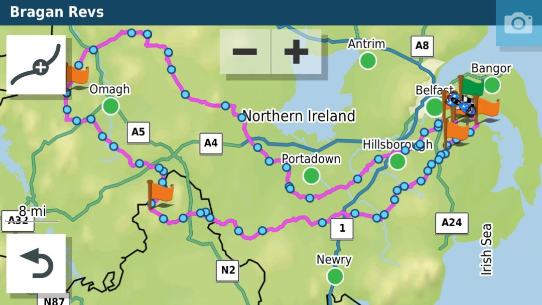
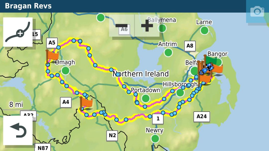
If you are doing a long out and back route with different but close together roads make sure that you have at least a Waypoint at the farthest end of the route. This will stop the unit shortcutting the route if you have to recalculate. In the old units they tried to get you to the next shaping point in the direction of travel...if another shaping point is closer to the XT it will just cut off a big lump of the route if you recalculate. For example in this route if you recalculated Just before where the 1 is on the map it would cut off the rest of the route and take you to Hillsborough if it was all shaping points and no way points which have to be gone through.
-
I've had Garmin GPS units for 20 years and the XT drove me nuts for the first year of ownership but I know its foibles now and can get it to do what I expect.
-
Jheath's resource on the Garmin Zumo forums is invaluable in understanding the unit.
https://www.zumouserforums.co.uk/viewtopic.php?t=1464&sid=680669f23fa3074472ce6f32c64f7de1
- For use with the XT I use GPX1.1 and have the track of the route visible as well. The track doesn't change from what is planned in MRA (or basecamp). Using CPX 1.1 you have all the waypoints (MRA speak/Shaping points (Garmin speak) as indicated by the little blue dots and the Via points as flags) shaping points can be bypassed and via points have to be visited (or skipped). As can be seen below I have a custom theme that makes the track line fatter than the magenta route line so that I can see if when the device is navigating.
-
Some people prefer GPX 1.2 because it gives an exact match to the route made in MRA. However, if you use this you really need to switch recalculation off as the route only contains a start and finish and if you go off route the unit will calculate the route to the endpoint by whatever parameters you have set (in my case fastest time.
-
When creating a route for the XT make sure to use plenty of waypoints/shaping points to force the route along the roads you want to be on. Garmin's new routing algorithm means that fastest routes= faster roads and it will try to route you onto a motorway or main road rather than taking a much shorter section of minor road.
That's probably enough for now. The XT unit has a few foibles but is a good navigation device. Increasingly now, I use the MRA navigation app via Android auto on My Africa twin to actually navigate with and my Zumo XT is relegated to handling POI's (particularly proximity warned ones) and tracks which it does much better than MRA.
-
-
Hey Folks,
I am pretty much still a novice at using MyRoute-app, and it has been tremendously helpful for planning my motorbike trips! I use a Garmin Zumo XT for navigation, but I've been having a small problem when I export my planned routes onto the device. I sometimes have lost a couple of waypoints or the route has slightly changed.
I have even tried using either GPX version 1.1, GPX version 1.2 and I still cannot get 100% consistency. So I’m hoping to hear from other users of the Zumo XT - what is the best export format or method to have the routes just as I planned in MyRoute-app?
I usually spend 90% of my time working on cloud projects (in fact, I just returned from Azure training in Hyderabad),sounds intresting right,
however, riding is my weekend passion and I would like to develop to improve on route planning and GPS syncing.Thanks in advance for any tips - I would truly appreciate your thoughts and experiences!
nevatik@nevatik Just to distil that a bit.
Using the XT I now do four things that I wouldn't have necessarily done with older Garmin Units I use/have used.
- I put a shaping point on every road I want to be on and use more shaping points than I previously would have if planning routes in basecamp or increasingly MRA routeplanner
- Always make a track and display the track and the route on the device so that I can spot any deviation(s).
- Have recalculation on prompted rather than automatic and use it sparingly
- Any route I'm using gets saved as an "Active Route" to avoid any issues with repeated u-turns if I have used recalculation at some point in the route.
-
Hey Folks,
I am pretty much still a novice at using MyRoute-app, and it has been tremendously helpful for planning my motorbike trips! I use a Garmin Zumo XT for navigation, but I've been having a small problem when I export my planned routes onto the device. I sometimes have lost a couple of waypoints or the route has slightly changed.
I have even tried using either GPX version 1.1, GPX version 1.2 and I still cannot get 100% consistency. So I’m hoping to hear from other users of the Zumo XT - what is the best export format or method to have the routes just as I planned in MyRoute-app?
I usually spend 90% of my time working on cloud projects (in fact, I just returned from Azure training in Hyderabad),sounds intresting right,
however, riding is my weekend passion and I would like to develop to improve on route planning and GPS syncing.Thanks in advance for any tips - I would truly appreciate your thoughts and experiences!
nevatik@nevatik I export the 1.2GPX version, make the track visible on the map in a nice color (anything but purple), set recalculating off and here you go. If you get lost (are off route) DO NOT PANIC!!!!
 but drive reLexed
  to the visible track/route. If there is a deviation, just follow it, because it will lead you to your planned route/track. And as soon as you are on the route again, (bike)life goes on
 ")
Met andere apps maak je een route, met MRA componeer je een route!
Ducati Monster 1200 met Garmin Zümo XT
Fiat 124 Spider/Camper Dethleffs met Navigation-App op Samsung Tab Active4 Pro
MRA Lifetime Gold -
@nevatik I export the 1.2GPX version, make the track visible on the map in a nice color (anything but purple), set recalculating off and here you go. If you get lost (are off route) DO NOT PANIC!!!!
but drive reLexed to the visible track/route. If there is a deviation, just follow it, because it will lead you to your planned route/track. And as soon as you are on the route again, (bike)life goes on since I'm using MyRoute-App, I don't use any longer Garmin XT. But if I remember correctly, then gpx 1.1 file format is supposed to be used for Garmin XT. The gpx 1.2 file format is supposed to be used for Garmin XT2 (and Tread series).
If you mix it up, result may be trouble with Shaping Points and Via Points on Sat Nav after transmitting.Nothing is impossible ;-)
In past: GARMIN Zumo 210->GARMIN Zumo 395->GARMIN XT=> now: DMD T865-X + MyRoute-App, LocusMaps, OsmAnd.
In past: GARMIN MapSource ->GARMIN BaseCamp->Tyre->Kurviger->Calimoto=> now: MRA-Routplanner. -
since I'm using MyRoute-App, I don't use any longer Garmin XT. But if I remember correctly, then gpx 1.1 file format is supposed to be used for Garmin XT. The gpx 1.2 file format is supposed to be used for Garmin XT2 (and Tread series).
If you mix it up, result may be trouble with Shaping Points and Via Points on Sat Nav after transmitting.@Guzzist That is not correct. the 1.2 format can be used on the XT. If you use the 1.2 format make shure that there are a couple of Viapoints in the route
Honda Goldwing GL1500,
Honda Silverwing GL 650
DMD2 T865X 8 inch Android tablet using MRA next for navigation
Garmin XT sold
Samsung S24FE mounted on a Quadlock and using Android Auto in my car -
@Guzzist That is not correct. the 1.2 format can be used on the XT. If you use the 1.2 format make shure that there are a couple of Viapoints in the route
@Marinus-van-Deudekom thank you for correction. But I did not wrote, it's not allowed/ not possible to use gpx 1.2. for transmission to Garmin XT. Technically you can - but there is a reason why we have the two different formats...
And XT (as the older one) is working verry different to the newer ones like XT2 and TreadNothing is impossible ;-)
In past: GARMIN Zumo 210->GARMIN Zumo 395->GARMIN XT=> now: DMD T865-X + MyRoute-App, LocusMaps, OsmAnd.
In past: GARMIN MapSource ->GARMIN BaseCamp->Tyre->Kurviger->Calimoto=> now: MRA-Routplanner. -
@Marinus-van-Deudekom thank you for correction. But I did not wrote, it's not allowed/ not possible to use gpx 1.2. for transmission to Garmin XT. Technically you can - but there is a reason why we have the two different formats...
And XT (as the older one) is working verry different to the newer ones like XT2 and Tread@Guzzist The 1.2 format is one that isonly possible in MRA and made special for the use of Garmin Devices
-
Hey Folks,
I am pretty much still a novice at using MyRoute-app, and it has been tremendously helpful for planning my motorbike trips! I use a Garmin Zumo XT for navigation, but I've been having a small problem when I export my planned routes onto the device. I sometimes have lost a couple of waypoints or the route has slightly changed.
I have even tried using either GPX version 1.1, GPX version 1.2 and I still cannot get 100% consistency. So I’m hoping to hear from other users of the Zumo XT - what is the best export format or method to have the routes just as I planned in MyRoute-app?
I usually spend 90% of my time working on cloud projects (in fact, I just returned from Azure training in Hyderabad),sounds intresting right,
however, riding is my weekend passion and I would like to develop to improve on route planning and GPS syncing.Thanks in advance for any tips - I would truly appreciate your thoughts and experiences!
nevatik@nevatik All very good advice given here. The XT can drive you crazy at first. Here's what I do that gives me very consistent results. Some of this has been stated already.
-
When planning online I use the HERE maps as it seems to give the most consistent results. Understand that when you import a route into the XT it WILL recalculate the route based on its settings (avoidances, faster vs shortest, etc.) I turn off the avoidances and select fastest vs shortest. I also use the GPX 1.1 route / track / poi format.
-
Put in enough shaping points so that the route is as unambiguous as possible. Be generous with them in areas where there are different ways to get from point a to point b.
-
As others have stated, when the route is imported the track is imported as well. Go to your tracks and make the track that matches the route visible, then when you pull up the route any deviations will be obvious. Play with the track's width and color to make it obvious when you're viewing it overlaid with the route.
-
Another very quick check to see if the XT's route matches your planned route in the planner is simply bring it up in the planner, look at the total distance, then bring it up on the XT and check the distance there as well. They should be VERY close. If not, check the route vs the track on the XT, make the necessary adjustments in the online planner, then delete the route and track from the XT and import them again. After doing this a few times you'll figure out what to look for (where to put your shaping points) and it will become a lot easier. I just planned a 3 week trip that I'm starting on tomorrow with my brother that includes 19 days of riding, and I only had 1 route that I had to modify and that was because of something really dumb that I had done leaving out some obviously needed shaping points.
-
The other very important thing (to me) that I'll mention is that once you have the route roughly laid out with the shaping points and via points, bring up the waypoint list in the online planner, select the first waypoint, hit the zoom button, ensure that it's exactly where you want it, move it if necessary, then click the right arrow to advance to the next shaping or via point, adjust as necessary, and continue through the entire route looking for any adjustments that are necessary. Move the shaping or via points away from any intersections that may cause confusion.
This can be annoying and frustrating at first, but with a little practice you'll figure out what the XT is doing and you'll be able to force it to do exactly what you want it to do!
Steve
-
-
I got tired of playing with 1.1/1.2 and resorted to exporting to XT using GPX 1.0. Seems to keep the fidelity of the route I planned and includes all of the waypoints and viapoints where I put them.
I keep the XT around as my 'belt and suspenders' approach. If my phone pukes, I have a dedicated satnav to fall back on. Just as long as I don't have to open Basecamp.
@Mike-Luca-0
Mike, I have spent hours trying to get XT to copy a MR route accurately.
The tracks aways work but convert to trip just will not follow.
Tried saving in 1.0 on an old route and it worked first time.
Thanks for the tip.
AlanM -
I have never had one problem with the 1.2 export to my XT. Recalculation set off, track visible.
-
I am Zumo XT user since few years, but just recently became MRA user (I bought Gold membership). In general MRA is exactly what I needed for as how I do routes.
I do route planning on Windows Chrome webpage and minor adjustments on Chrome browser on android tablet (shortcut as an app to have full screen) that I take with me on longer few days trips. I then use andorid MRA app on my phone to export as version 1.1 and open with Garmin Drive, then bluetooth to export to Zumo XT. It works.
As someone suggested, Jheath's in Zumo forum is a must-read.
Also you have to have MRA gold membership because you want to use HERE maps.
You have to understand the difference between VIA (MRA = hand) and SHAPPING (MRA = tear) points, also to know that adding a waypoint for a city is not just search of city in the search bar, but to add waypoint directly to the road you want to drive by in that city... and use quite a lot of waypoints for a trip. And to have similar settings (avoid hightways, etc.) with MRA and Garmin XT...
A good tip is also about starting point... It should be a like 50 or 100 m in front of your actual start point so that you surely drive through it.
I also noticed that Zumo XT only show limited characters of route name in a Trip Planner. But if I name the route without spaces, I get to see longer names in Zumo XT, so it is better for organizing...
I am still learning, but so far... everything as planned
")
-
@nevatik I export the 1.2GPX version, make the track visible on the map in a nice color (anything but purple), set recalculating off and here you go. If you get lost (are off route) DO NOT PANIC!!!!
but drive reLexed to the visible track/route. If there is a deviation, just follow it, because it will lead you to your planned route/track. And as soon as you are on the route again, (bike)life goes on @Lex.Kloet.RX Hi Lex, This can be a good suggestion. However what to do when you already drove 100 km and you accidently shutdown your active route? How do you the start the route again. In my opinion there are only three options Start, End or Nearest. And if so, due the lack of shaping points, it will always bring you through a direct route to the nearest point. So then you missing the fun. Or are there other options that i am not aware of?
-
@Lex.Kloet.RX Hi Lex, This can be a good suggestion. However what to do when you already drove 100 km and you accidently shutdown your active route? How do you the start the route again. In my opinion there are only three options Start, End or Nearest. And if so, due the lack of shaping points, it will always bring you through a direct route to the nearest point. So then you missing the fun. Or are there other options that i am not aware of?
@Sandor-Veth when you want to restart you have to be ON the route and then you will be brought to the next waypoint following the route not a direct line. It has been a while, but I think it is "End".
Met andere apps maak je een route, met MRA componeer je een route!
Ducati Monster 1200 met Garmin Zümo XT
Fiat 124 Spider/Camper Dethleffs met Navigation-App op Samsung Tab Active4 Pro
MRA Lifetime Gold -
@Sandor-Veth when you want to restart you have to be ON the route and then you will be brought to the next waypoint following the route not a direct line. It has been a while, but I think it is "End".
@Lex.Kloet.RX Thanks
-
 undefined Mzokk referenced this topic on
Hello! It looks like you're interested in this conversation, but you don't have an account yet.
Getting fed up of having to scroll through the same posts each visit? When you register for an account, you'll always come back to exactly where you were before, and choose to be notified of new replies (either via email, or push notification). You'll also be able to save bookmarks and upvote posts to show your appreciation to other community members.
With your input, this post could be even better 💗
Register Login-
71156.4k
-
020487
-
026441
-
0351
-
1215287
-
19564
-
0246
-
07269