Has the Web planer been updated? GPX file now not importing Waypoints from GPX, only Track
-
Last Oct I was able to simply import our Route and Track form the Groups GPX file and It would display the 20 or so Via points embedded in the GPX file. This year for the same event, with the same provided GPX file all I can get are the start and finish waypoints and the track. Converting it to a track is not useful as this just inserts random waypoints to ensure turn by turn follows the track.
What I would normally do is fix the via points by adding notes etc then use my Gold sub to add extra waypoints to make sure the route didn't change. Then I would export to my XT2 and use the MRA phone App as the main navigator.
My Bad, but I'm totally confused about what has changed between the two events. In between I have been creating routes directly in MRA web and running them on the phone so I didn't notice the change, or have I just forgotten how to do this?
Help would be appreciated. I don't wish to have to move the file via Basecamp as that would be a backward move the I purchased MRA to avoid. I'm on a Mac, so Basecamp is slow and buggy. And anyway, I still need it in MRA for the phone Navigation as well as the XT2.
R1200RS, Nav VI, Zumo XT2, iPhone. — Plot the Track, Go the Distance
-
Last Oct I was able to simply import our Route and Track form the Groups GPX file and It would display the 20 or so Via points embedded in the GPX file. This year for the same event, with the same provided GPX file all I can get are the start and finish waypoints and the track. Converting it to a track is not useful as this just inserts random waypoints to ensure turn by turn follows the track.
What I would normally do is fix the via points by adding notes etc then use my Gold sub to add extra waypoints to make sure the route didn't change. Then I would export to my XT2 and use the MRA phone App as the main navigator.
My Bad, but I'm totally confused about what has changed between the two events. In between I have been creating routes directly in MRA web and running them on the phone so I didn't notice the change, or have I just forgotten how to do this?
Help would be appreciated. I don't wish to have to move the file via Basecamp as that would be a backward move the I purchased MRA to avoid. I'm on a Mac, so Basecamp is slow and buggy. And anyway, I still need it in MRA for the phone Navigation as well as the XT2.
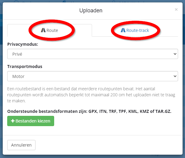
@Neil-Bartlett, you can upload routes and route-tracks in seperate tabs of the upload windows. Most GPX files contain both, but some don't.
I am not aware of any recent changes on this feature.
If you share a download link to the GPX file, I can test it for you.I am just an enthusiastic MRA user, and hope you will be one too!
Most motorcycle problems are caused by the nut that connects the handlebar to the saddle.
Check out RideSleepRepeat.eu, a biker community for sharing stays across Europe
-
Hi @Neil-Bartlett as @Con-Hennekens says not much has changed with regard MRA & gpx file import / export, it should work & you should be able to get the via points & shaping points if you want
I suspect where things may be going awry is at the very first stage of the process, it would help if you could expand on where & between what areas / devices you are "importing"?
When you say Group GPX, can you confirm you mean your copying a gpx from a Group within the MRA web site & planner?
Apologies I am just a bit confused over where your starting fromBlackView BV7100, Android 12
Navigate "Routes as Tracks" in Offline mode with Offline Maps
No Wifi, no internet, no interruptions, works well -
@Brian-McG said in Has the Web planer been updated? GPX file now not importing Waypoints from GPX, only Track:
you should be able to get the via points & shaping points if you want
Yes, if @Neil-Bartlett uses the Route tab from the picture above, and then only if the waypoints are indeed present in the GPX file. Some tour-operators have the nasty habit of only delivering the track in their GPX files, because they think that is the best way to ensure everyone has the same "route". And they may actually be right, but not for people with MRA skills...
")
-
The URL where I down load the files from is:
https://www.distanceriders.org.nz/2024-1kc.htmlBelow is a copy of the list of available files to Download. I should be able to d/l the last file and get the track and the waypoints needing to be photographed. I can place it in BaseCamp and it appears to be correct but in MRA the route does not show.
Here is a copy of the instructions at the URL:
Downloadable GPX bundles, download and use these in your GPS or your Navigational app:Track only - Download Link - Southern Track only (.gpx)
Great for ReverRoute and Checkpoints - Download Link - Southern Route and Checkpoints (.gpx)
Great for InRouteJust Checkpoints - Download Link - Southern Checkpoints only (.gpx)
Great for PoI ViewerCheckpoints and Track combined - Download Link - Southern Checkpoints and Track (.gpx)
Great for MRA appThey are clearly defined when you go to the URL above. I only copied them here to show what to look for on the NZ Distance Riders website. It is imperative that we follow the route as proscribed by the Track.
R1200RS, Nav VI, Zumo XT2, iPhone. — Plot the Track, Go the Distance
-
The URL where I down load the files from is:
https://www.distanceriders.org.nz/2024-1kc.htmlBelow is a copy of the list of available files to Download. I should be able to d/l the last file and get the track and the waypoints needing to be photographed. I can place it in BaseCamp and it appears to be correct but in MRA the route does not show.
Here is a copy of the instructions at the URL:
Downloadable GPX bundles, download and use these in your GPS or your Navigational app:Track only - Download Link - Southern Track only (.gpx)
Great for ReverRoute and Checkpoints - Download Link - Southern Route and Checkpoints (.gpx)
Great for InRouteJust Checkpoints - Download Link - Southern Checkpoints only (.gpx)
Great for PoI ViewerCheckpoints and Track combined - Download Link - Southern Checkpoints and Track (.gpx)
Great for MRA appThey are clearly defined when you go to the URL above. I only copied them here to show what to look for on the NZ Distance Riders website. It is imperative that we follow the route as proscribed by the Track.
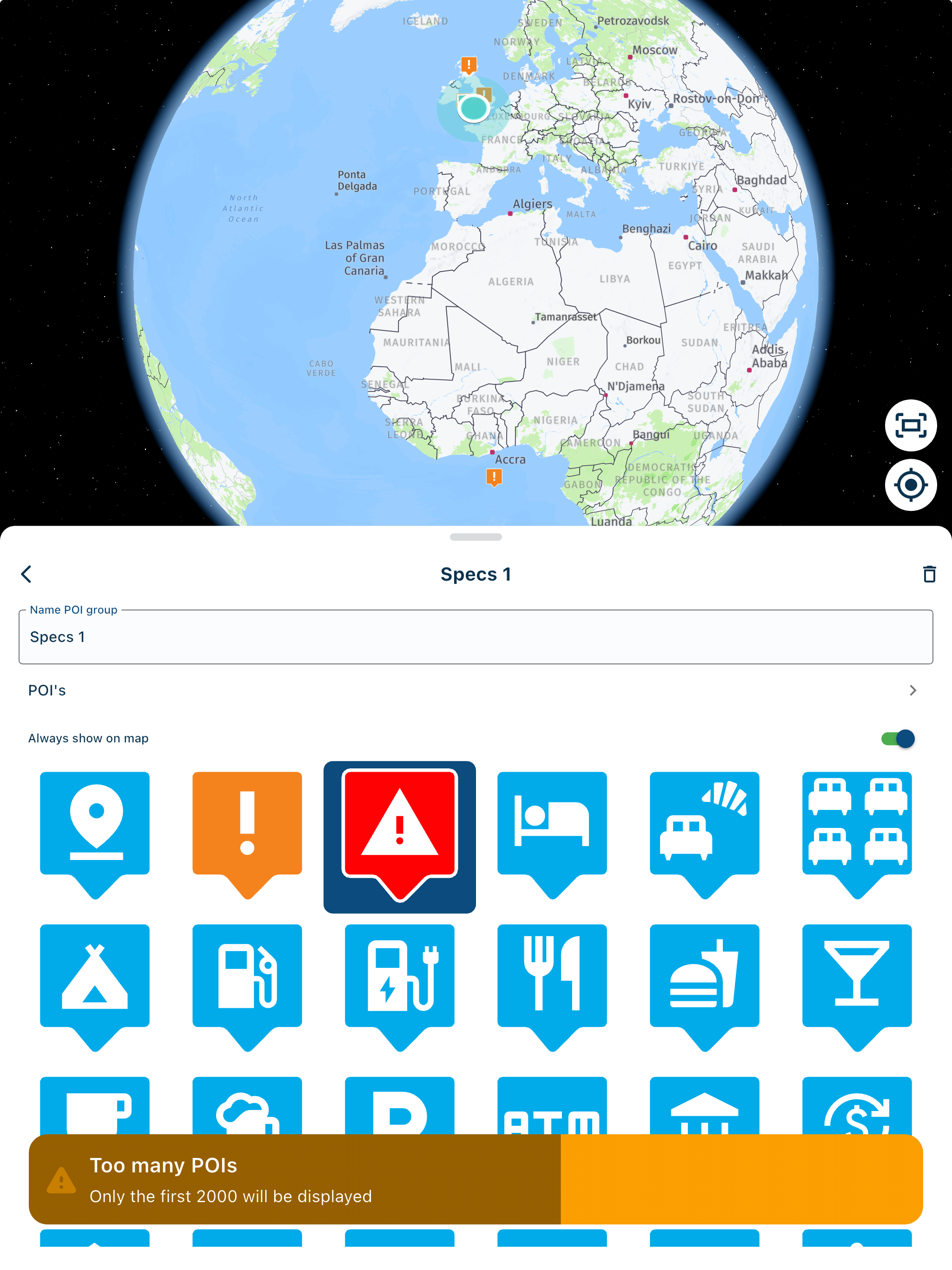
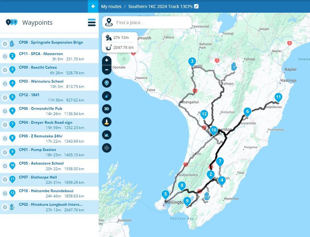
@Neil-Bartlett I have imported one of them and seems correctly:
-
The waypoints are all there but the order is incorrect and the track is not showing, unfortunately. Last year everything was in order and the correct track was shown.
R1200RS, Nav VI, Zumo XT2, iPhone. — Plot the Track, Go the Distance
-
The waypoints are all there but the order is incorrect and the track is not showing, unfortunately. Last year everything was in order and the correct track was shown.
@Neil-Bartlett Sorry, I understood that there is now waypoints imported at all, only track.
-
Hi @Neil-Bartlett as @Con-Hennekens says not much has changed with regard MRA & gpx file import / export, it should work & you should be able to get the via points & shaping points if you want
I suspect where things may be going awry is at the very first stage of the process, it would help if you could expand on where & between what areas / devices you are "importing"?
When you say Group GPX, can you confirm you mean your copying a gpx from a Group within the MRA web site & planner?
Apologies I am just a bit confused over where your starting from@Brian-McG The GPX file is made by the organisers of the Distance ride group in NZ for our rides. I think they are produced within Garmin Basecamp which is able to export a GPX file. The GPX files are made available from the NZ Distance Riders Web page and we copy the GPX to our devices from there. I copied the GPX file to MRA web, added my fuel stops and changed to via points with notes. This year they made accommodations for some other software (inRoute etc) by tailoring the GPX files to suit their limitations, as well as the same GPX file that worked with MRA last year for myself and others I have encouraged to purchase MRA. Unfortunately, it doesn't seem to be correct this year and we are trying to fix it.
-
@Neil-Bartlett, you can upload routes and route-tracks in seperate tabs of the upload windows. Most GPX files contain both, but some don't.
I am not aware of any recent changes on this feature.
If you share a download link to the GPX file, I can test it for you.@Con-Hennekens Thanks for responding. My understanding is that the GPX file noted as working with MRA contains both route and Track as on the Garmin you can have a map showing both in different colours so you can ensure the Turn by turn route does not deviate from the desired track contained in the GPX file. I have an XT2 Garmin as a back-up to main guidance unit which is my iPhone and MRA Nav. I have posted the URL for the GPX files and the combined Track Route file should be the last on the list for the southern Ride out of Wellington. Stanislaw has done a trial from that file and the waypoints have become scrambled and the track does not seem to be showing. The order can be fixed but the route has errors, I think because the track has not been imported.
R1200RS, Nav VI, Zumo XT2, iPhone. — Plot the Track, Go the Distance
-
@Con-Hennekens Thanks for responding. My understanding is that the GPX file noted as working with MRA contains both route and Track as on the Garmin you can have a map showing both in different colours so you can ensure the Turn by turn route does not deviate from the desired track contained in the GPX file. I have an XT2 Garmin as a back-up to main guidance unit which is my iPhone and MRA Nav. I have posted the URL for the GPX files and the combined Track Route file should be the last on the list for the southern Ride out of Wellington. Stanislaw has done a trial from that file and the waypoints have become scrambled and the track does not seem to be showing. The order can be fixed but the route has errors, I think because the track has not been imported.
@Neil-Bartlett, I have seen the scrambling of waypoints often, I suspect especially Basecamp exports suffer from this, but I don't use that anymore so I cannot say for certain. MRA imports these WP's in the order they appear in the file. Some software seems to export them in a numbered order not following the same logic as MRA uses. WP10 can appear before WP2 in the ordering in the file. Usually it can easily be re-ordered using the left column.
Then there is the very common problem where the created route does not completely comply to the track. That is quite logical, because who knows what routing logic was used to create the track, and on which map it has been done. Did they use shortest or quickest, avoid toll roads, maye even traffic info interfered with the course of the track... You will have to add waypoints to make the route compliant to the track.
Usually I import both the track and the route. I then take a look at the waypoint info, to see if there is any sensible info in them. If they are just placed waypoints with no further extra info, I delete them all and start drawing my own route using self-placed waypoints.
Hello! It looks like you're interested in this conversation, but you don't have an account yet.
Getting fed up of having to scroll through the same posts each visit? When you register for an account, you'll always come back to exactly where you were before, and choose to be notified of new replies (either via email, or push notification). You'll also be able to save bookmarks and upvote posts to show your appreciation to other community members.
With your input, this post could be even better 💗
Register Login-
014209
-
1936.2k
-
0239
-
17438.7k
-
0363
-
255613.0k
-
0948
-
0122