Timmelsjoch HERE / MRA mapping problem...
-
Hi Tom,
great plan, but that route is a mess. No offense, but there are so much more misplaced waypoints...^^
I do agree that there may be an issue with Timmelsjoch seasonal closing depending on what map you are using. HERE can do it correct or not when reloading on my PC.
BTW: in my opinion, you are missing some of the best experience of those roads by returning at the top of some passes.
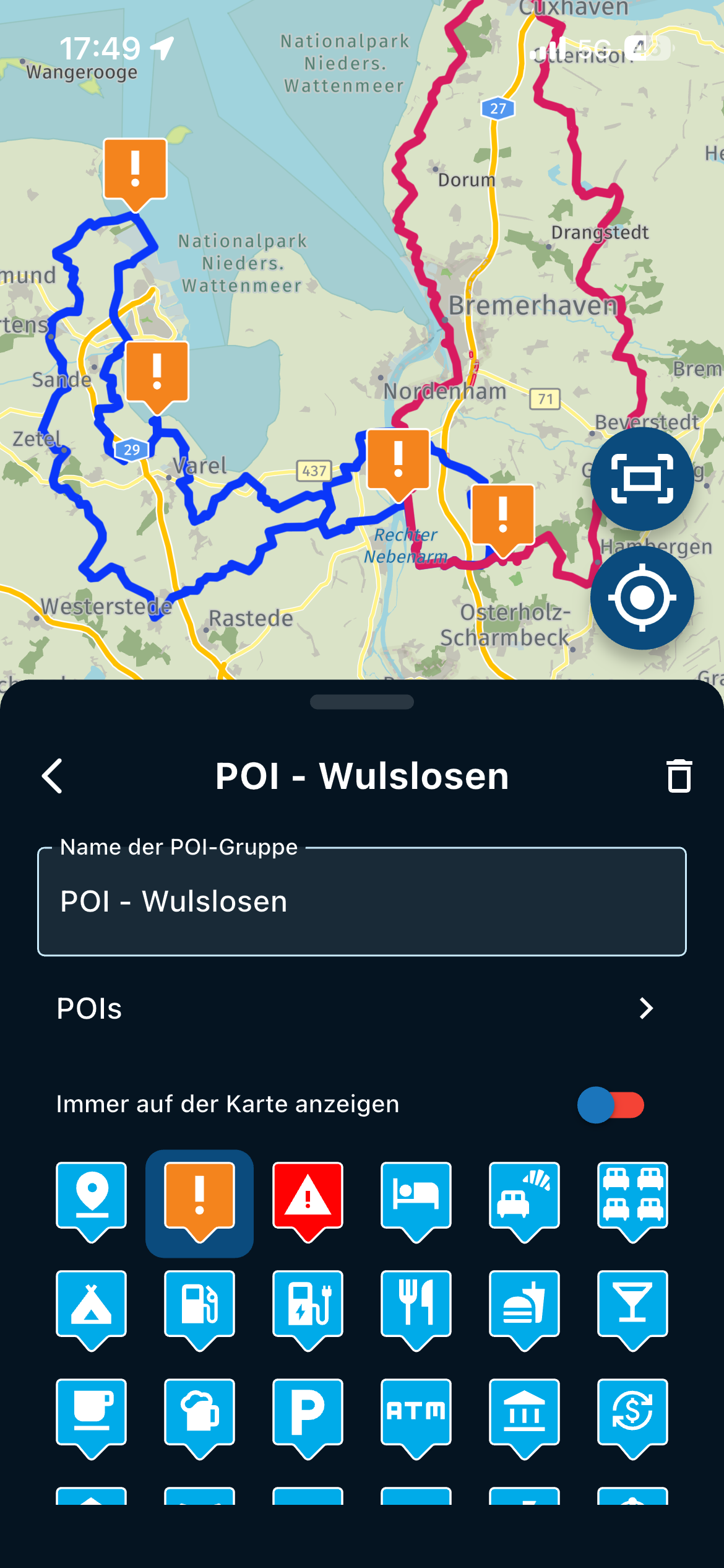
For your consideration a personal POI list with more than 600 entries that may give some additional options.
")
https://www.google.com/maps/d/u/0/edit?mid=1wRIVqBxCOUcmLwVvuTIejBr5bh_r4pA&usp=sharingRegards from Austria,
AndréHi André,
I have had a quick look at your POI map - wow!
You say I am "missing some of the best experience of those roads by returning at the top of some passes." Please help me with these.
Your map has so many POIs, but no route. Please tell me some of your favourite locations near my route that stand out for you, and I will try to change my journey.
Thank you,
Tom.Porsche 911 and VW Transporter T6.1 running CarPlay.
iPhone 17 Pro running Waze and MRA.
MRA Routeplanner on web via Mac -
Hi André,
I have had a quick look at your POI map - wow!
You say I am "missing some of the best experience of those roads by returning at the top of some passes." Please help me with these.
Your map has so many POIs, but no route. Please tell me some of your favourite locations near my route that stand out for you, and I will try to change my journey.
Thank you,
Tom.@Tom-Grzelinski
The Timmelsjoch problem is back, even with very few waypoints, all correctly positioned on the roads! So, maybe these were not the problem?See the map here:
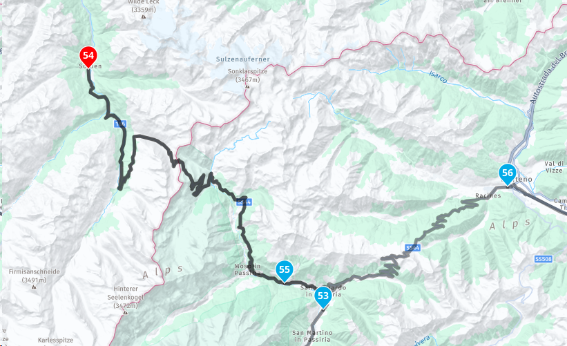
https://www.myrouteapp.com/en/social/route/8734835?mode=shareThe problem is between points 53 to 56. I want to drive from 53 to 56 and then back down the same road to 56. I do not want to be routed up to Innsbruck!
If I delete a waypoint, like 55, then the map works as it should. But then later (5 mins) it reverts to routing up to Innsbruck.
Can anyone from MRA shed light on this problem that @Erdna has experienced too?
Porsche 911 and VW Transporter T6.1 running CarPlay.
iPhone 17 Pro running Waze and MRA.
MRA Routeplanner on web via Mac -
@richtea999
RichTea - thank you! You are welcome to join me in September. I will be doing this in the car though as I am not sure I could ride my Ducati 998 that far without my arms falling off!This is my rough map and I will then go in and check each waypoint and move them, especially at junctions, but thanks for pointing those out.
Your 'one other tip' is awesome, thank you for this, that will save a lot of time.
Cheers, Tom.
@Tom-Grzelinski WHAT??? Come on mate, I did these kind of tours on a 900SS, 916 and a 999


Tips: split every day in its own route, you have more overview.
Change your "highlights" in your route (red, yellow and green) into waypoints. In stead a upsidedown waterdrop change it into a hand. In that case you will be notified when you arrive at that point.Met andere apps maak je een route, met MRA componeer je een route!
Ducati Monster 1200 met Garmin Zümo XT
Fiat 124 Spider/Camper Dethleffs met Navigation-App op Samsung Tab Active4 Pro
MRA Lifetime Gold -
@Tom-Grzelinski
The Timmelsjoch problem is back, even with very few waypoints, all correctly positioned on the roads! So, maybe these were not the problem?See the map here:
https://www.myrouteapp.com/en/social/route/8734835?mode=shareThe problem is between points 53 to 56. I want to drive from 53 to 56 and then back down the same road to 56. I do not want to be routed up to Innsbruck!
If I delete a waypoint, like 55, then the map works as it should. But then later (5 mins) it reverts to routing up to Innsbruck.
Can anyone from MRA shed light on this problem that @Erdna has experienced too?
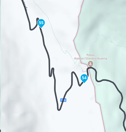
@Tom-Grzelinski the problem lies in a little piece of road on the Timmelsjoch in the direction of Sölden. If you place the shapingpoints like this, the problem should be solved. Try to toggle with point 54, drag it somewhat to the south and you will see that the problem comes back again. The markers in my example should solve it.
Met andere apps maak je een route, met MRA componeer je een route!
Ducati Monster 1200 met Garmin Zümo XT
Fiat 124 Spider/Camper Dethleffs met Navigation-App op Samsung Tab Active4 Pro
MRA Lifetime Gold -
@Tom-Grzelinski WHAT??? Come on mate, I did these kind of tours on a 900SS, 916 and a 999
Tips: split every day in its own route, you have more overview.
Change your "highlights" in your route (red, yellow and green) into waypoints. In stead a upsidedown waterdrop change it into a hand. In that case you will be notified when you arrive at that point.@travellexwill-cyou
Thanks Will, it was always my intention to cut this in to separate days. I think I said that earlier. This is my overview of the whole route.Ha ha, I find my 749RS so much more comfortable than the 998, but unfortunately (or maybe fortunately for my license?) it is not road legal

-
@Tom-Grzelinski the problem lies in a little piece of road on the Timmelsjoch in the direction of Sölden. If you place the shapingpoints like this, the problem should be solved. Try to toggle with point 54, drag it somewhat to the south and you will see that the problem comes back again. The markers in my example should solve it.
@travellexwill-cyou
Thanks Will. I will try this but I am not sure this is the total problem.When I was first building the route I got to 53 then searched for Timmelsjoch in MRA, choosing this:
Timmelsjoch High Alpine Road
46.911210, 11.087460and placed a waypoint. Straight away the map would not route between 53 and this point. I had to add lots and lots of waypoints between 53 and this waypoint to make MRA make a direct route.
So, I think maybe the whole area has a problem. Maybe seasonal closing is not being ignored here?
This is not a massive problem for my trip as when I break the map in to separate days, it should work. And also I am intelligent enough not to get up in the morning and let the map take me to Innsbruck
 but I think the problem needs investigating and fixing in MRA or HERE, whichever is at fault.
Thanks for your help

Porsche 911 and VW Transporter T6.1 running CarPlay.
iPhone 17 Pro running Waze and MRA.
MRA Routeplanner on web via Mac -
@travellexwill-cyou
Thanks Will. I will try this but I am not sure this is the total problem.When I was first building the route I got to 53 then searched for Timmelsjoch in MRA, choosing this:
Timmelsjoch High Alpine Road
46.911210, 11.087460and placed a waypoint. Straight away the map would not route between 53 and this point. I had to add lots and lots of waypoints between 53 and this waypoint to make MRA make a direct route.
So, I think maybe the whole area has a problem. Maybe seasonal closing is not being ignored here?
This is not a massive problem for my trip as when I break the map in to separate days, it should work. And also I am intelligent enough not to get up in the morning and let the map take me to Innsbruck
but I think the problem needs investigating and fixing in MRA or HERE, whichever is at fault.Thanks for your help
@Tom-Grzelinski there is something strange with the Timmelsjoch, that is correct, because I deleted the 2 points, and the route stayed the same

But the problem is only a small strip around the top. It might be the seasonal closing, but in some way that is working, because when I disable (or able) the seasonal closure I see this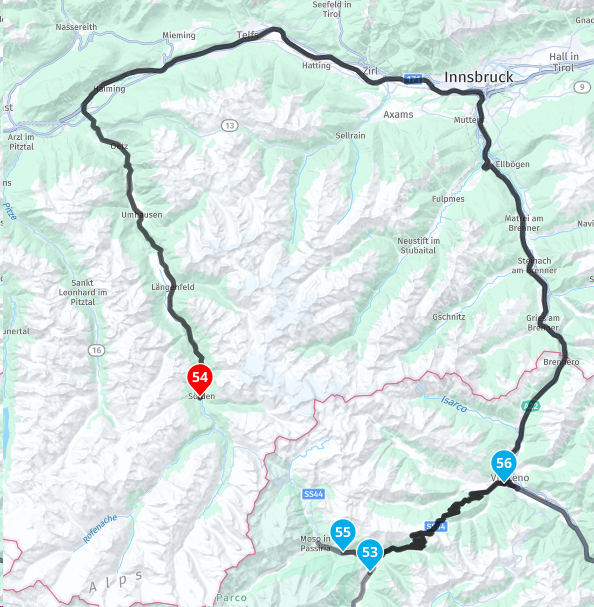 , so yeah it is working, but yeah, there is something spooky at the Timmelsjoch. Just travel to the place, enjoy it all, because it is fabulous over there and ignore the problems on your navigation. By the way Basecamp has the same problems with this stupid mountain.
Greetings,
LexMet andere apps maak je een route, met MRA componeer je een route!
Ducati Monster 1200 met Garmin Zümo XT
Fiat 124 Spider/Camper Dethleffs met Navigation-App op Samsung Tab Active4 Pro
MRA Lifetime Gold -
I noticed this anomaly last year. I did write something on the forum.
it is a lesson learned for me, it is not a major issue, as long as you are aware when planning the routes.
if you did not check them and send them to friends, then you would be parting ways at the approach road to the passes.I planned my routes, around the Alps. then save and close the MRA planner.
When I went back a few days later, to add another route or to amend a route, I found some routes had changed, especially on the passes, without my input.
I do not know why this happened.what I will add, after end of May, this stopped happening, so it has to be something to with the passes being shut in the winter.
also, as you have found, it made no difference if seasonal closure was ticked/disbaled or not.I now make sure that when I plan a route, if its the final version, I will make a track out of it, that way I always have the original planned route.
I have not made routes in the alps this year so I am unaware if this still happens, but it looks like it does.
I am touring the Scottish highlands/Lake District/Yorkshire Dales, so no high passes, but still awesome.
to achieve, we must first attempt ✌️
K1600 GTL
Oukitel RT3
iPhone 13 Pro, carpuride 702b -
@Tom-Grzelinski there is something strange with the Timmelsjoch, that is correct, because I deleted the 2 points, and the route stayed the same
But the problem is only a small strip around the top. It might be the seasonal closing, but in some way that is working, because when I disable (or able) the seasonal closure I see this , so yeah it is working, but yeah, there is something spooky at the Timmelsjoch. Just travel to the place, enjoy it all, because it is fabulous over there and ignore the problems on your navigation. By the way Basecamp has the same problems with this stupid mountain.
Greetings,
Lex@travellexwill-cyou
Thanks Lex. Sorry I read your name wrong!Porsche 911 and VW Transporter T6.1 running CarPlay.
iPhone 17 Pro running Waze and MRA.
MRA Routeplanner on web via Mac -
I noticed this anomaly last year. I did write something on the forum.
it is a lesson learned for me, it is not a major issue, as long as you are aware when planning the routes.
if you did not check them and send them to friends, then you would be parting ways at the approach road to the passes.I planned my routes, around the Alps. then save and close the MRA planner.
When I went back a few days later, to add another route or to amend a route, I found some routes had changed, especially on the passes, without my input.
I do not know why this happened.what I will add, after end of May, this stopped happening, so it has to be something to with the passes being shut in the winter.
also, as you have found, it made no difference if seasonal closure was ticked/disbaled or not.I now make sure that when I plan a route, if its the final version, I will make a track out of it, that way I always have the original planned route.
I have not made routes in the alps this year so I am unaware if this still happens, but it looks like it does.
I am touring the Scottish highlands/Lake District/Yorkshire Dales, so no high passes, but still awesome.
@paul69
Thanks Paul. Enjoy Scotland, we will be doing some of Scotland next year in our camper. -
@travellexwill-cyou
Thanks Lex. Sorry I read your name wrong!@Tom-Grzelinski no worries it's OK, since you are riding a Ducati
PECCO!!!


Hello! It looks like you're interested in this conversation, but you don't have an account yet.
Getting fed up of having to scroll through the same posts each visit? When you register for an account, you'll always come back to exactly where you were before, and choose to be notified of new replies (either via email, or push notification). You'll also be able to save bookmarks and upvote posts to show your appreciation to other community members.
With your input, this post could be even better 💗
Register Login-
2428
-
012221
-
0226
-
09802
-
210129
-
06536.3k
-
43169