New Beta! (v3.2.16)
-
Hey everyone!

Today is the day for another big update! We've fixed the most crucial issue in the app and added / tweaked a lot of functionalities! We're pretty sure that you will be very pleased with this update

It will be available somewhere between today and tomorrow
")
Obviously we gave this update a good test about which you can read here: https://forum.myrouteapp.com/topic/4379/alpha-test-result
Position delay
Finally the day is here that we can announce that the position delay in the app has been fixed! Not a lot of images to share or to write about but this is the most important change of the update! I’d simply recommend that you all go out and enjoy the weather to experience it for yourself.
App walkthrough
As we are approaching the release, we need to make sure that users understand the app! Therefore we’ve added two walkthroughs in the app
- The first explains the basic functionalities of the app previously known as the “Mobile” app. This will allows users to understand where they can find which features.
- The second walkthrough explains the layout of the navigation module and the important nifty little features you can find there. For example tapping the ETA field.
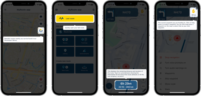
Can the walkthroughs be skipped? No! It only takes a few click and we believe it adds a lot of information about the app, such that everybody should see it at least once

Improved tilt / zoom (dynamic camera)
In almost every update we tried to accomplish this. However..... we were stupid and missed a very stupid little detail. This explained all the user reports where they mentioned that the map would not be tilted at all So now we can finally say that the dynamic camera correctly tilts in all scenario’s. This means that you will always have a tilted view! You don’t want that? Keep on reading!
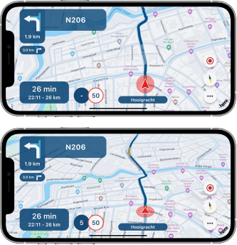
Fixed camera & zoom buttons
You knew that tapping the compass would cycle between the dynamic camera (automatic tilt & zoom) and the fixed camera (top-down view). In the fixed mode, north would always be facing up. This has been changed so that your heading faces up (like the dynamic camera).
In this camera mode the camera will always show a top-down (no tilt) view and you may choose your own zoom level using the new zoom buttons!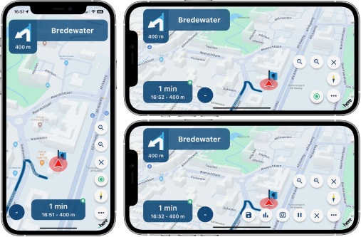
UI rework of tracking button
Adding the previously mentioned zoom buttons was a pain in the ass regarding the layout. Therefore we reworked some buttons to make better use of available space Tapping the tracklog button now pops out the different options. This allows a more scalable solution for adding buttons to the map. The same type of button has been used for the zoom buttons.
Building layout
Some people prefer 3D buildings on the map (like the app was until today) but others hated it. You can now choose this for yourself!
- “Off” doesn’t show any buildings
- “2D” only shows the footprint of buildings (this is now the default setting)
- “3D” shows them like you were used to
We thought it would be best to make 2D the default as this is what most people seem to prefer.
Where can you change this setting? Map layout might be a good place to look.
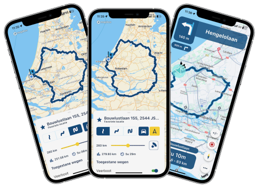
Long routes issue
The app wasn’t able to calculate the fastest route to a destination far away (> 600km). This has now been fixed!
A nice extra is that the calculated fastest route now matches the selected suggested route when starting navigation.Traffic preference
In the functional navigation settings there was a setting to toggle “Traffic information”. This has been renamed to “Traffic aware route calculation”. When enabled the map will show traffic jams and takes them into account when calculating the route
Using routes from the website? The behavior in the app and routeplanner are aligned! This ensures that you always drive the route exactly as you planned it.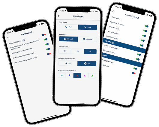
Improved waypoint list
The waypoint list is a great tool to show the passed and remainder of your route.
As of this update it actually opens at the upcoming waypoint, the menu cannot be closed accidentally anymore and we’ve added a visual distinction between the passed, current and upcoming waypoints.Resume navigation issue
When resuming a previous navigation session sometimes the incorrect waypoint was used. This issue has been fixed!
Bad internet & login page
If you had a bad internet connection the login page would sometimes appear. We’ve made improvements to prevent this from happening. If you still encounter it, please let us know!Creating scenic routes & round tours
Fixed two major frustrations regarding the route creation menu:- It cannot be closed anymore by swiping it down
- When changing the travel mode the calculated route now also updates appropriately
Offline mode indicator
Are you driving in offline mode? We’ve added a nice little indicator to show this.Track navigation validation
When loading a track in navigation, you sometimes see warnings about errors in the route. This popup is purely informational but can be frustrating if you drive a lot of tracks. If you really don’t care about the warning, it can be turned off from the functional navigation settingsUsing TomTom / OSM routes
If you open a route created in the TomTom / OSM map for navigation, we now display a warning that the calculated route might differ from the planned route. This makes sense because the app uses HERE as foundation of the navigation. You may choose to accept any (possible) differences for what it is or load it as track. Using track navigation ensures you drive exactly what you planned but you loose all waypoint functionality.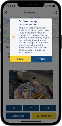
What's next?
The release is approaching fast! With this update we are confident that the app is ready for a great release
In the remaining two weeks the most important issues we will work on and make sure that they are fixed are:- Offline maps download stability / lack of progress
- Voice prompt stability & configuration options
- Battery usage
Obviously we still got some other minor features we want to implement but the above will be the focus. Besides that, we'll keep on processing all your feedback
Looking forward to your experiences with this update!
Best,
Corjan -
 undefined Corjan Meijerink referenced this topic on
-
Hey everyone!
Today is the day for another big update! We've fixed the most crucial issue in the app and added / tweaked a lot of functionalities! We're pretty sure that you will be very pleased with this update
It will be available somewhere between today and tomorrow
Obviously we gave this update a good test about which you can read here: https://forum.myrouteapp.com/topic/4379/alpha-test-result
Position delay
Finally the day is here that we can announce that the position delay in the app has been fixed! Not a lot of images to share or to write about but this is the most important change of the update! I’d simply recommend that you all go out and enjoy the weather to experience it for yourself.App walkthrough
As we are approaching the release, we need to make sure that users understand the app! Therefore we’ve added two walkthroughs in the app- The first explains the basic functionalities of the app previously known as the “Mobile” app. This will allows users to understand where they can find which features.
- The second walkthrough explains the layout of the navigation module and the important nifty little features you can find there. For example tapping the ETA field.
Can the walkthroughs be skipped? No! It only takes a few click and we believe it adds a lot of information about the app, such that everybody should see it at least once
Improved tilt / zoom (dynamic camera)
In almost every update we tried to accomplish this. However..... we were stupid and missed a very stupid little detail. This explained all the user reports where they mentioned that the map would not be tilted at all So now we can finally say that the dynamic camera correctly tilts in all scenario’s. This means that you will always have a tilted view! You don’t want that? Keep on reading!Fixed camera & zoom buttons
You knew that tapping the compass would cycle between the dynamic camera (automatic tilt & zoom) and the fixed camera (top-down view). In the fixed mode, north would always be facing up. This has been changed so that your heading faces up (like the dynamic camera).
In this camera mode the camera will always show a top-down (no tilt) view and you may choose your own zoom level using the new zoom buttons!UI rework of tracking button
Adding the previously mentioned zoom buttons was a pain in the ass regarding the layout. Therefore we reworked some buttons to make better use of available space Tapping the tracklog button now pops out the different options. This allows a more scalable solution for adding buttons to the map. The same type of button has been used for the zoom buttons.Building layout
Some people prefer 3D buildings on the map (like the app was until today) but others hated it. You can now choose this for yourself!- “Off” doesn’t show any buildings
- “2D” only shows the footprint of buildings (this is now the default setting)
- “3D” shows them like you were used to
We thought it would be best to make 2D the default as this is what most people seem to prefer.
Where can you change this setting? Map layout might be a good place to look.
Long routes issue
The app wasn’t able to calculate the fastest route to a destination far away (> 600km). This has now been fixed!
A nice extra is that the calculated fastest route now matches the selected suggested route when starting navigation.Traffic preference
In the functional navigation settings there was a setting to toggle “Traffic information”. This has been renamed to “Traffic aware route calculation”. When enabled the map will show traffic jams and takes them into account when calculating the route
Using routes from the website? The behavior in the app and routeplanner are aligned! This ensures that you always drive the route exactly as you planned it.Improved waypoint list
The waypoint list is a great tool to show the passed and remainder of your route.
As of this update it actually opens at the upcoming waypoint, the menu cannot be closed accidentally anymore and we’ve added a visual distinction between the passed, current and upcoming waypoints.Resume navigation issue
When resuming a previous navigation session sometimes the incorrect waypoint was used. This issue has been fixed!Bad internet & login page
If you had a bad internet connection the login page would sometimes appear. We’ve made improvements to prevent this from happening. If you still encounter it, please let us know!Creating scenic routes & round tours
Fixed two major frustrations regarding the route creation menu:- It cannot be closed anymore by swiping it down
- When changing the travel mode the calculated route now also updates appropriately
Offline mode indicator
Are you driving in offline mode? We’ve added a nice little indicator to show this.Track navigation validation
When loading a track in navigation, you sometimes see warnings about errors in the route. This popup is purely informational but can be frustrating if you drive a lot of tracks. If you really don’t care about the warning, it can be turned off from the functional navigation settingsUsing TomTom / OSM routes
If you open a route created in the TomTom / OSM map for navigation, we now display a warning that the calculated route might differ from the planned route. This makes sense because the app uses HERE as foundation of the navigation. You may choose to accept any (possible) differences for what it is or load it as track. Using track navigation ensures you drive exactly what you planned but you loose all waypoint functionality.What's next?
The release is approaching fast! With this update we are confident that the app is ready for a great release
In the remaining two weeks the most important issues we will work on and make sure that they are fixed are:- Offline maps download stability / lack of progress
- Voice prompt stability & configuration options
- Battery usage
Obviously we still got some other minor features we want to implement but the above will be the focus. Besides that, we'll keep on processing all your feedback
Looking forward to your experiences with this update!
Best,
Corjan@Corjan-Meijerink It's getting tedious to have to keep saying we're impressed once again by the amount of progress ... but yet here i go: I'm once again impressed! Wow!

-
Hey everyone!
Today is the day for another big update! We've fixed the most crucial issue in the app and added / tweaked a lot of functionalities! We're pretty sure that you will be very pleased with this update
It will be available somewhere between today and tomorrow
Obviously we gave this update a good test about which you can read here: https://forum.myrouteapp.com/topic/4379/alpha-test-result
Position delay
Finally the day is here that we can announce that the position delay in the app has been fixed! Not a lot of images to share or to write about but this is the most important change of the update! I’d simply recommend that you all go out and enjoy the weather to experience it for yourself.App walkthrough
As we are approaching the release, we need to make sure that users understand the app! Therefore we’ve added two walkthroughs in the app- The first explains the basic functionalities of the app previously known as the “Mobile” app. This will allows users to understand where they can find which features.
- The second walkthrough explains the layout of the navigation module and the important nifty little features you can find there. For example tapping the ETA field.
Can the walkthroughs be skipped? No! It only takes a few click and we believe it adds a lot of information about the app, such that everybody should see it at least once
Improved tilt / zoom (dynamic camera)
In almost every update we tried to accomplish this. However..... we were stupid and missed a very stupid little detail. This explained all the user reports where they mentioned that the map would not be tilted at all So now we can finally say that the dynamic camera correctly tilts in all scenario’s. This means that you will always have a tilted view! You don’t want that? Keep on reading!Fixed camera & zoom buttons
You knew that tapping the compass would cycle between the dynamic camera (automatic tilt & zoom) and the fixed camera (top-down view). In the fixed mode, north would always be facing up. This has been changed so that your heading faces up (like the dynamic camera).
In this camera mode the camera will always show a top-down (no tilt) view and you may choose your own zoom level using the new zoom buttons!UI rework of tracking button
Adding the previously mentioned zoom buttons was a pain in the ass regarding the layout. Therefore we reworked some buttons to make better use of available space Tapping the tracklog button now pops out the different options. This allows a more scalable solution for adding buttons to the map. The same type of button has been used for the zoom buttons.Building layout
Some people prefer 3D buildings on the map (like the app was until today) but others hated it. You can now choose this for yourself!- “Off” doesn’t show any buildings
- “2D” only shows the footprint of buildings (this is now the default setting)
- “3D” shows them like you were used to
We thought it would be best to make 2D the default as this is what most people seem to prefer.
Where can you change this setting? Map layout might be a good place to look.
Long routes issue
The app wasn’t able to calculate the fastest route to a destination far away (> 600km). This has now been fixed!
A nice extra is that the calculated fastest route now matches the selected suggested route when starting navigation.Traffic preference
In the functional navigation settings there was a setting to toggle “Traffic information”. This has been renamed to “Traffic aware route calculation”. When enabled the map will show traffic jams and takes them into account when calculating the route
Using routes from the website? The behavior in the app and routeplanner are aligned! This ensures that you always drive the route exactly as you planned it.Improved waypoint list
The waypoint list is a great tool to show the passed and remainder of your route.
As of this update it actually opens at the upcoming waypoint, the menu cannot be closed accidentally anymore and we’ve added a visual distinction between the passed, current and upcoming waypoints.Resume navigation issue
When resuming a previous navigation session sometimes the incorrect waypoint was used. This issue has been fixed!Bad internet & login page
If you had a bad internet connection the login page would sometimes appear. We’ve made improvements to prevent this from happening. If you still encounter it, please let us know!Creating scenic routes & round tours
Fixed two major frustrations regarding the route creation menu:- It cannot be closed anymore by swiping it down
- When changing the travel mode the calculated route now also updates appropriately
Offline mode indicator
Are you driving in offline mode? We’ve added a nice little indicator to show this.Track navigation validation
When loading a track in navigation, you sometimes see warnings about errors in the route. This popup is purely informational but can be frustrating if you drive a lot of tracks. If you really don’t care about the warning, it can be turned off from the functional navigation settingsUsing TomTom / OSM routes
If you open a route created in the TomTom / OSM map for navigation, we now display a warning that the calculated route might differ from the planned route. This makes sense because the app uses HERE as foundation of the navigation. You may choose to accept any (possible) differences for what it is or load it as track. Using track navigation ensures you drive exactly what you planned but you loose all waypoint functionality.What's next?
The release is approaching fast! With this update we are confident that the app is ready for a great release
In the remaining two weeks the most important issues we will work on and make sure that they are fixed are:- Offline maps download stability / lack of progress
- Voice prompt stability & configuration options
- Battery usage
Obviously we still got some other minor features we want to implement but the above will be the focus. Besides that, we'll keep on processing all your feedback
Looking forward to your experiences with this update!
Best,
Corjan@Corjan-Meijerink : Dankeschön dafür

-
@Corjan-Meijerink Fantastisch werk!
 Deze week naar de Eifel en Luxemburg geweest om daar te toeren met de ondersteuning van de nieuwe app. Op een paar kleine dingen na werkt de app nu al behoorlijk goed.
 -
Nice, deze week met de motor en mra route gereden, mooie display en goed te zien. Ook fijn dat na stops de route direct wordt opgenomen om verder te zetten. Eindelijk van dat Garmin gedoe vanaf van terug rijden en herberekenen afzetten en nieuwe route proberen in te laden.
-
Hey everyone!
Today is the day for another big update! We've fixed the most crucial issue in the app and added / tweaked a lot of functionalities! We're pretty sure that you will be very pleased with this update
It will be available somewhere between today and tomorrow
Obviously we gave this update a good test about which you can read here: https://forum.myrouteapp.com/topic/4379/alpha-test-result
Position delay
Finally the day is here that we can announce that the position delay in the app has been fixed! Not a lot of images to share or to write about but this is the most important change of the update! I’d simply recommend that you all go out and enjoy the weather to experience it for yourself.App walkthrough
As we are approaching the release, we need to make sure that users understand the app! Therefore we’ve added two walkthroughs in the app- The first explains the basic functionalities of the app previously known as the “Mobile” app. This will allows users to understand where they can find which features.
- The second walkthrough explains the layout of the navigation module and the important nifty little features you can find there. For example tapping the ETA field.
Can the walkthroughs be skipped? No! It only takes a few click and we believe it adds a lot of information about the app, such that everybody should see it at least once
Improved tilt / zoom (dynamic camera)
In almost every update we tried to accomplish this. However..... we were stupid and missed a very stupid little detail. This explained all the user reports where they mentioned that the map would not be tilted at all So now we can finally say that the dynamic camera correctly tilts in all scenario’s. This means that you will always have a tilted view! You don’t want that? Keep on reading!Fixed camera & zoom buttons
You knew that tapping the compass would cycle between the dynamic camera (automatic tilt & zoom) and the fixed camera (top-down view). In the fixed mode, north would always be facing up. This has been changed so that your heading faces up (like the dynamic camera).
In this camera mode the camera will always show a top-down (no tilt) view and you may choose your own zoom level using the new zoom buttons!UI rework of tracking button
Adding the previously mentioned zoom buttons was a pain in the ass regarding the layout. Therefore we reworked some buttons to make better use of available space Tapping the tracklog button now pops out the different options. This allows a more scalable solution for adding buttons to the map. The same type of button has been used for the zoom buttons.Building layout
Some people prefer 3D buildings on the map (like the app was until today) but others hated it. You can now choose this for yourself!- “Off” doesn’t show any buildings
- “2D” only shows the footprint of buildings (this is now the default setting)
- “3D” shows them like you were used to
We thought it would be best to make 2D the default as this is what most people seem to prefer.
Where can you change this setting? Map layout might be a good place to look.
Long routes issue
The app wasn’t able to calculate the fastest route to a destination far away (> 600km). This has now been fixed!
A nice extra is that the calculated fastest route now matches the selected suggested route when starting navigation.Traffic preference
In the functional navigation settings there was a setting to toggle “Traffic information”. This has been renamed to “Traffic aware route calculation”. When enabled the map will show traffic jams and takes them into account when calculating the route
Using routes from the website? The behavior in the app and routeplanner are aligned! This ensures that you always drive the route exactly as you planned it.Improved waypoint list
The waypoint list is a great tool to show the passed and remainder of your route.
As of this update it actually opens at the upcoming waypoint, the menu cannot be closed accidentally anymore and we’ve added a visual distinction between the passed, current and upcoming waypoints.Resume navigation issue
When resuming a previous navigation session sometimes the incorrect waypoint was used. This issue has been fixed!Bad internet & login page
If you had a bad internet connection the login page would sometimes appear. We’ve made improvements to prevent this from happening. If you still encounter it, please let us know!Creating scenic routes & round tours
Fixed two major frustrations regarding the route creation menu:- It cannot be closed anymore by swiping it down
- When changing the travel mode the calculated route now also updates appropriately
Offline mode indicator
Are you driving in offline mode? We’ve added a nice little indicator to show this.Track navigation validation
When loading a track in navigation, you sometimes see warnings about errors in the route. This popup is purely informational but can be frustrating if you drive a lot of tracks. If you really don’t care about the warning, it can be turned off from the functional navigation settingsUsing TomTom / OSM routes
If you open a route created in the TomTom / OSM map for navigation, we now display a warning that the calculated route might differ from the planned route. This makes sense because the app uses HERE as foundation of the navigation. You may choose to accept any (possible) differences for what it is or load it as track. Using track navigation ensures you drive exactly what you planned but you loose all waypoint functionality.What's next?
The release is approaching fast! With this update we are confident that the app is ready for a great release
In the remaining two weeks the most important issues we will work on and make sure that they are fixed are:- Offline maps download stability / lack of progress
- Voice prompt stability & configuration options
- Battery usage
Obviously we still got some other minor features we want to implement but the above will be the focus. Besides that, we'll keep on processing all your feedback
Looking forward to your experiences with this update!
Best,
CorjanGoed bezig mannen
-
Impressive list again!
-
Hey everyone!
Today is the day for another big update! We've fixed the most crucial issue in the app and added / tweaked a lot of functionalities! We're pretty sure that you will be very pleased with this update
It will be available somewhere between today and tomorrow
Obviously we gave this update a good test about which you can read here: https://forum.myrouteapp.com/topic/4379/alpha-test-result
Position delay
Finally the day is here that we can announce that the position delay in the app has been fixed! Not a lot of images to share or to write about but this is the most important change of the update! I’d simply recommend that you all go out and enjoy the weather to experience it for yourself.App walkthrough
As we are approaching the release, we need to make sure that users understand the app! Therefore we’ve added two walkthroughs in the app- The first explains the basic functionalities of the app previously known as the “Mobile” app. This will allows users to understand where they can find which features.
- The second walkthrough explains the layout of the navigation module and the important nifty little features you can find there. For example tapping the ETA field.
Can the walkthroughs be skipped? No! It only takes a few click and we believe it adds a lot of information about the app, such that everybody should see it at least once
Improved tilt / zoom (dynamic camera)
In almost every update we tried to accomplish this. However..... we were stupid and missed a very stupid little detail. This explained all the user reports where they mentioned that the map would not be tilted at all So now we can finally say that the dynamic camera correctly tilts in all scenario’s. This means that you will always have a tilted view! You don’t want that? Keep on reading!Fixed camera & zoom buttons
You knew that tapping the compass would cycle between the dynamic camera (automatic tilt & zoom) and the fixed camera (top-down view). In the fixed mode, north would always be facing up. This has been changed so that your heading faces up (like the dynamic camera).
In this camera mode the camera will always show a top-down (no tilt) view and you may choose your own zoom level using the new zoom buttons!UI rework of tracking button
Adding the previously mentioned zoom buttons was a pain in the ass regarding the layout. Therefore we reworked some buttons to make better use of available space Tapping the tracklog button now pops out the different options. This allows a more scalable solution for adding buttons to the map. The same type of button has been used for the zoom buttons.Building layout
Some people prefer 3D buildings on the map (like the app was until today) but others hated it. You can now choose this for yourself!- “Off” doesn’t show any buildings
- “2D” only shows the footprint of buildings (this is now the default setting)
- “3D” shows them like you were used to
We thought it would be best to make 2D the default as this is what most people seem to prefer.
Where can you change this setting? Map layout might be a good place to look.
Long routes issue
The app wasn’t able to calculate the fastest route to a destination far away (> 600km). This has now been fixed!
A nice extra is that the calculated fastest route now matches the selected suggested route when starting navigation.Traffic preference
In the functional navigation settings there was a setting to toggle “Traffic information”. This has been renamed to “Traffic aware route calculation”. When enabled the map will show traffic jams and takes them into account when calculating the route
Using routes from the website? The behavior in the app and routeplanner are aligned! This ensures that you always drive the route exactly as you planned it.Improved waypoint list
The waypoint list is a great tool to show the passed and remainder of your route.
As of this update it actually opens at the upcoming waypoint, the menu cannot be closed accidentally anymore and we’ve added a visual distinction between the passed, current and upcoming waypoints.Resume navigation issue
When resuming a previous navigation session sometimes the incorrect waypoint was used. This issue has been fixed!Bad internet & login page
If you had a bad internet connection the login page would sometimes appear. We’ve made improvements to prevent this from happening. If you still encounter it, please let us know!Creating scenic routes & round tours
Fixed two major frustrations regarding the route creation menu:- It cannot be closed anymore by swiping it down
- When changing the travel mode the calculated route now also updates appropriately
Offline mode indicator
Are you driving in offline mode? We’ve added a nice little indicator to show this.Track navigation validation
When loading a track in navigation, you sometimes see warnings about errors in the route. This popup is purely informational but can be frustrating if you drive a lot of tracks. If you really don’t care about the warning, it can be turned off from the functional navigation settingsUsing TomTom / OSM routes
If you open a route created in the TomTom / OSM map for navigation, we now display a warning that the calculated route might differ from the planned route. This makes sense because the app uses HERE as foundation of the navigation. You may choose to accept any (possible) differences for what it is or load it as track. Using track navigation ensures you drive exactly what you planned but you loose all waypoint functionality.What's next?
The release is approaching fast! With this update we are confident that the app is ready for a great release
In the remaining two weeks the most important issues we will work on and make sure that they are fixed are:- Offline maps download stability / lack of progress
- Voice prompt stability & configuration options
- Battery usage
Obviously we still got some other minor features we want to implement but the above will be the focus. Besides that, we'll keep on processing all your feedback
Looking forward to your experiences with this update!
Best,
Corjan@Corjan-Meijerink Well done, brilliant work!
-
 undefined Con Hennekens referenced this topic on
-
Hey everyone!
Today is the day for another big update! We've fixed the most crucial issue in the app and added / tweaked a lot of functionalities! We're pretty sure that you will be very pleased with this update
It will be available somewhere between today and tomorrow
Obviously we gave this update a good test about which you can read here: https://forum.myrouteapp.com/topic/4379/alpha-test-result
Position delay
Finally the day is here that we can announce that the position delay in the app has been fixed! Not a lot of images to share or to write about but this is the most important change of the update! I’d simply recommend that you all go out and enjoy the weather to experience it for yourself.App walkthrough
As we are approaching the release, we need to make sure that users understand the app! Therefore we’ve added two walkthroughs in the app- The first explains the basic functionalities of the app previously known as the “Mobile” app. This will allows users to understand where they can find which features.
- The second walkthrough explains the layout of the navigation module and the important nifty little features you can find there. For example tapping the ETA field.
Can the walkthroughs be skipped? No! It only takes a few click and we believe it adds a lot of information about the app, such that everybody should see it at least once
Improved tilt / zoom (dynamic camera)
In almost every update we tried to accomplish this. However..... we were stupid and missed a very stupid little detail. This explained all the user reports where they mentioned that the map would not be tilted at all So now we can finally say that the dynamic camera correctly tilts in all scenario’s. This means that you will always have a tilted view! You don’t want that? Keep on reading!Fixed camera & zoom buttons
You knew that tapping the compass would cycle between the dynamic camera (automatic tilt & zoom) and the fixed camera (top-down view). In the fixed mode, north would always be facing up. This has been changed so that your heading faces up (like the dynamic camera).
In this camera mode the camera will always show a top-down (no tilt) view and you may choose your own zoom level using the new zoom buttons!UI rework of tracking button
Adding the previously mentioned zoom buttons was a pain in the ass regarding the layout. Therefore we reworked some buttons to make better use of available space Tapping the tracklog button now pops out the different options. This allows a more scalable solution for adding buttons to the map. The same type of button has been used for the zoom buttons.Building layout
Some people prefer 3D buildings on the map (like the app was until today) but others hated it. You can now choose this for yourself!- “Off” doesn’t show any buildings
- “2D” only shows the footprint of buildings (this is now the default setting)
- “3D” shows them like you were used to
We thought it would be best to make 2D the default as this is what most people seem to prefer.
Where can you change this setting? Map layout might be a good place to look.
Long routes issue
The app wasn’t able to calculate the fastest route to a destination far away (> 600km). This has now been fixed!
A nice extra is that the calculated fastest route now matches the selected suggested route when starting navigation.Traffic preference
In the functional navigation settings there was a setting to toggle “Traffic information”. This has been renamed to “Traffic aware route calculation”. When enabled the map will show traffic jams and takes them into account when calculating the route
Using routes from the website? The behavior in the app and routeplanner are aligned! This ensures that you always drive the route exactly as you planned it.Improved waypoint list
The waypoint list is a great tool to show the passed and remainder of your route.
As of this update it actually opens at the upcoming waypoint, the menu cannot be closed accidentally anymore and we’ve added a visual distinction between the passed, current and upcoming waypoints.Resume navigation issue
When resuming a previous navigation session sometimes the incorrect waypoint was used. This issue has been fixed!Bad internet & login page
If you had a bad internet connection the login page would sometimes appear. We’ve made improvements to prevent this from happening. If you still encounter it, please let us know!Creating scenic routes & round tours
Fixed two major frustrations regarding the route creation menu:- It cannot be closed anymore by swiping it down
- When changing the travel mode the calculated route now also updates appropriately
Offline mode indicator
Are you driving in offline mode? We’ve added a nice little indicator to show this.Track navigation validation
When loading a track in navigation, you sometimes see warnings about errors in the route. This popup is purely informational but can be frustrating if you drive a lot of tracks. If you really don’t care about the warning, it can be turned off from the functional navigation settingsUsing TomTom / OSM routes
If you open a route created in the TomTom / OSM map for navigation, we now display a warning that the calculated route might differ from the planned route. This makes sense because the app uses HERE as foundation of the navigation. You may choose to accept any (possible) differences for what it is or load it as track. Using track navigation ensures you drive exactly what you planned but you loose all waypoint functionality.What's next?
The release is approaching fast! With this update we are confident that the app is ready for a great release
In the remaining two weeks the most important issues we will work on and make sure that they are fixed are:- Offline maps download stability / lack of progress
- Voice prompt stability & configuration options
- Battery usage
Obviously we still got some other minor features we want to implement but the above will be the focus. Besides that, we'll keep on processing all your feedback
Looking forward to your experiences with this update!
Best,
Corjan@Corjan-Meijerink geweldige update weer, hoop handige functies die ik hier in Polen al met plezier gebruik zoals de 3D en het zoomen.
Op de Samsung Active Tab 3 heb ik al een poos geen probleem meer met battery life, blijft keurig tot 100% bijladen, zelfs op volledig helder scherm
Beyond impressed, ook Joost natuurlijk -
Wow, again GREATE WORK, well done!
I will test it the next days on the International V-Strom Meeting.
-
Hey everyone!
Today is the day for another big update! We've fixed the most crucial issue in the app and added / tweaked a lot of functionalities! We're pretty sure that you will be very pleased with this update
It will be available somewhere between today and tomorrow
Obviously we gave this update a good test about which you can read here: https://forum.myrouteapp.com/topic/4379/alpha-test-result
Position delay
Finally the day is here that we can announce that the position delay in the app has been fixed! Not a lot of images to share or to write about but this is the most important change of the update! I’d simply recommend that you all go out and enjoy the weather to experience it for yourself.App walkthrough
As we are approaching the release, we need to make sure that users understand the app! Therefore we’ve added two walkthroughs in the app- The first explains the basic functionalities of the app previously known as the “Mobile” app. This will allows users to understand where they can find which features.
- The second walkthrough explains the layout of the navigation module and the important nifty little features you can find there. For example tapping the ETA field.
Can the walkthroughs be skipped? No! It only takes a few click and we believe it adds a lot of information about the app, such that everybody should see it at least once
Improved tilt / zoom (dynamic camera)
In almost every update we tried to accomplish this. However..... we were stupid and missed a very stupid little detail. This explained all the user reports where they mentioned that the map would not be tilted at all So now we can finally say that the dynamic camera correctly tilts in all scenario’s. This means that you will always have a tilted view! You don’t want that? Keep on reading!Fixed camera & zoom buttons
You knew that tapping the compass would cycle between the dynamic camera (automatic tilt & zoom) and the fixed camera (top-down view). In the fixed mode, north would always be facing up. This has been changed so that your heading faces up (like the dynamic camera).
In this camera mode the camera will always show a top-down (no tilt) view and you may choose your own zoom level using the new zoom buttons!UI rework of tracking button
Adding the previously mentioned zoom buttons was a pain in the ass regarding the layout. Therefore we reworked some buttons to make better use of available space Tapping the tracklog button now pops out the different options. This allows a more scalable solution for adding buttons to the map. The same type of button has been used for the zoom buttons.Building layout
Some people prefer 3D buildings on the map (like the app was until today) but others hated it. You can now choose this for yourself!- “Off” doesn’t show any buildings
- “2D” only shows the footprint of buildings (this is now the default setting)
- “3D” shows them like you were used to
We thought it would be best to make 2D the default as this is what most people seem to prefer.
Where can you change this setting? Map layout might be a good place to look.
Long routes issue
The app wasn’t able to calculate the fastest route to a destination far away (> 600km). This has now been fixed!
A nice extra is that the calculated fastest route now matches the selected suggested route when starting navigation.Traffic preference
In the functional navigation settings there was a setting to toggle “Traffic information”. This has been renamed to “Traffic aware route calculation”. When enabled the map will show traffic jams and takes them into account when calculating the route
Using routes from the website? The behavior in the app and routeplanner are aligned! This ensures that you always drive the route exactly as you planned it.Improved waypoint list
The waypoint list is a great tool to show the passed and remainder of your route.
As of this update it actually opens at the upcoming waypoint, the menu cannot be closed accidentally anymore and we’ve added a visual distinction between the passed, current and upcoming waypoints.Resume navigation issue
When resuming a previous navigation session sometimes the incorrect waypoint was used. This issue has been fixed!Bad internet & login page
If you had a bad internet connection the login page would sometimes appear. We’ve made improvements to prevent this from happening. If you still encounter it, please let us know!Creating scenic routes & round tours
Fixed two major frustrations regarding the route creation menu:- It cannot be closed anymore by swiping it down
- When changing the travel mode the calculated route now also updates appropriately
Offline mode indicator
Are you driving in offline mode? We’ve added a nice little indicator to show this.Track navigation validation
When loading a track in navigation, you sometimes see warnings about errors in the route. This popup is purely informational but can be frustrating if you drive a lot of tracks. If you really don’t care about the warning, it can be turned off from the functional navigation settingsUsing TomTom / OSM routes
If you open a route created in the TomTom / OSM map for navigation, we now display a warning that the calculated route might differ from the planned route. This makes sense because the app uses HERE as foundation of the navigation. You may choose to accept any (possible) differences for what it is or load it as track. Using track navigation ensures you drive exactly what you planned but you loose all waypoint functionality.What's next?
The release is approaching fast! With this update we are confident that the app is ready for a great release
In the remaining two weeks the most important issues we will work on and make sure that they are fixed are:- Offline maps download stability / lack of progress
- Voice prompt stability & configuration options
- Battery usage
Obviously we still got some other minor features we want to implement but the above will be the focus. Besides that, we'll keep on processing all your feedback
Looking forward to your experiences with this update!
Best,
CorjanSimply Awesome
-
Hey everyone!
Today is the day for another big update! We've fixed the most crucial issue in the app and added / tweaked a lot of functionalities! We're pretty sure that you will be very pleased with this update
It will be available somewhere between today and tomorrow
Obviously we gave this update a good test about which you can read here: https://forum.myrouteapp.com/topic/4379/alpha-test-result
Position delay
Finally the day is here that we can announce that the position delay in the app has been fixed! Not a lot of images to share or to write about but this is the most important change of the update! I’d simply recommend that you all go out and enjoy the weather to experience it for yourself.App walkthrough
As we are approaching the release, we need to make sure that users understand the app! Therefore we’ve added two walkthroughs in the app- The first explains the basic functionalities of the app previously known as the “Mobile” app. This will allows users to understand where they can find which features.
- The second walkthrough explains the layout of the navigation module and the important nifty little features you can find there. For example tapping the ETA field.
Can the walkthroughs be skipped? No! It only takes a few click and we believe it adds a lot of information about the app, such that everybody should see it at least once
Improved tilt / zoom (dynamic camera)
In almost every update we tried to accomplish this. However..... we were stupid and missed a very stupid little detail. This explained all the user reports where they mentioned that the map would not be tilted at all So now we can finally say that the dynamic camera correctly tilts in all scenario’s. This means that you will always have a tilted view! You don’t want that? Keep on reading!Fixed camera & zoom buttons
You knew that tapping the compass would cycle between the dynamic camera (automatic tilt & zoom) and the fixed camera (top-down view). In the fixed mode, north would always be facing up. This has been changed so that your heading faces up (like the dynamic camera).
In this camera mode the camera will always show a top-down (no tilt) view and you may choose your own zoom level using the new zoom buttons!UI rework of tracking button
Adding the previously mentioned zoom buttons was a pain in the ass regarding the layout. Therefore we reworked some buttons to make better use of available space Tapping the tracklog button now pops out the different options. This allows a more scalable solution for adding buttons to the map. The same type of button has been used for the zoom buttons.Building layout
Some people prefer 3D buildings on the map (like the app was until today) but others hated it. You can now choose this for yourself!- “Off” doesn’t show any buildings
- “2D” only shows the footprint of buildings (this is now the default setting)
- “3D” shows them like you were used to
We thought it would be best to make 2D the default as this is what most people seem to prefer.
Where can you change this setting? Map layout might be a good place to look.
Long routes issue
The app wasn’t able to calculate the fastest route to a destination far away (> 600km). This has now been fixed!
A nice extra is that the calculated fastest route now matches the selected suggested route when starting navigation.Traffic preference
In the functional navigation settings there was a setting to toggle “Traffic information”. This has been renamed to “Traffic aware route calculation”. When enabled the map will show traffic jams and takes them into account when calculating the route
Using routes from the website? The behavior in the app and routeplanner are aligned! This ensures that you always drive the route exactly as you planned it.Improved waypoint list
The waypoint list is a great tool to show the passed and remainder of your route.
As of this update it actually opens at the upcoming waypoint, the menu cannot be closed accidentally anymore and we’ve added a visual distinction between the passed, current and upcoming waypoints.Resume navigation issue
When resuming a previous navigation session sometimes the incorrect waypoint was used. This issue has been fixed!Bad internet & login page
If you had a bad internet connection the login page would sometimes appear. We’ve made improvements to prevent this from happening. If you still encounter it, please let us know!Creating scenic routes & round tours
Fixed two major frustrations regarding the route creation menu:- It cannot be closed anymore by swiping it down
- When changing the travel mode the calculated route now also updates appropriately
Offline mode indicator
Are you driving in offline mode? We’ve added a nice little indicator to show this.Track navigation validation
When loading a track in navigation, you sometimes see warnings about errors in the route. This popup is purely informational but can be frustrating if you drive a lot of tracks. If you really don’t care about the warning, it can be turned off from the functional navigation settingsUsing TomTom / OSM routes
If you open a route created in the TomTom / OSM map for navigation, we now display a warning that the calculated route might differ from the planned route. This makes sense because the app uses HERE as foundation of the navigation. You may choose to accept any (possible) differences for what it is or load it as track. Using track navigation ensures you drive exactly what you planned but you loose all waypoint functionality.What's next?
The release is approaching fast! With this update we are confident that the app is ready for a great release
In the remaining two weeks the most important issues we will work on and make sure that they are fixed are:- Offline maps download stability / lack of progress
- Voice prompt stability & configuration options
- Battery usage
Obviously we still got some other minor features we want to implement but the above will be the focus. Besides that, we'll keep on processing all your feedback
Looking forward to your experiences with this update!
Best,
Corjan@Corjan-Meijerink Fantastic! The best keeps getting better! Great Work!
-
Hey everyone!
Today is the day for another big update! We've fixed the most crucial issue in the app and added / tweaked a lot of functionalities! We're pretty sure that you will be very pleased with this update
It will be available somewhere between today and tomorrow
Obviously we gave this update a good test about which you can read here: https://forum.myrouteapp.com/topic/4379/alpha-test-result
Position delay
Finally the day is here that we can announce that the position delay in the app has been fixed! Not a lot of images to share or to write about but this is the most important change of the update! I’d simply recommend that you all go out and enjoy the weather to experience it for yourself.App walkthrough
As we are approaching the release, we need to make sure that users understand the app! Therefore we’ve added two walkthroughs in the app- The first explains the basic functionalities of the app previously known as the “Mobile” app. This will allows users to understand where they can find which features.
- The second walkthrough explains the layout of the navigation module and the important nifty little features you can find there. For example tapping the ETA field.
Can the walkthroughs be skipped? No! It only takes a few click and we believe it adds a lot of information about the app, such that everybody should see it at least once
Improved tilt / zoom (dynamic camera)
In almost every update we tried to accomplish this. However..... we were stupid and missed a very stupid little detail. This explained all the user reports where they mentioned that the map would not be tilted at all So now we can finally say that the dynamic camera correctly tilts in all scenario’s. This means that you will always have a tilted view! You don’t want that? Keep on reading!Fixed camera & zoom buttons
You knew that tapping the compass would cycle between the dynamic camera (automatic tilt & zoom) and the fixed camera (top-down view). In the fixed mode, north would always be facing up. This has been changed so that your heading faces up (like the dynamic camera).
In this camera mode the camera will always show a top-down (no tilt) view and you may choose your own zoom level using the new zoom buttons!UI rework of tracking button
Adding the previously mentioned zoom buttons was a pain in the ass regarding the layout. Therefore we reworked some buttons to make better use of available space Tapping the tracklog button now pops out the different options. This allows a more scalable solution for adding buttons to the map. The same type of button has been used for the zoom buttons.Building layout
Some people prefer 3D buildings on the map (like the app was until today) but others hated it. You can now choose this for yourself!- “Off” doesn’t show any buildings
- “2D” only shows the footprint of buildings (this is now the default setting)
- “3D” shows them like you were used to
We thought it would be best to make 2D the default as this is what most people seem to prefer.
Where can you change this setting? Map layout might be a good place to look.
Long routes issue
The app wasn’t able to calculate the fastest route to a destination far away (> 600km). This has now been fixed!
A nice extra is that the calculated fastest route now matches the selected suggested route when starting navigation.Traffic preference
In the functional navigation settings there was a setting to toggle “Traffic information”. This has been renamed to “Traffic aware route calculation”. When enabled the map will show traffic jams and takes them into account when calculating the route
Using routes from the website? The behavior in the app and routeplanner are aligned! This ensures that you always drive the route exactly as you planned it.Improved waypoint list
The waypoint list is a great tool to show the passed and remainder of your route.
As of this update it actually opens at the upcoming waypoint, the menu cannot be closed accidentally anymore and we’ve added a visual distinction between the passed, current and upcoming waypoints.Resume navigation issue
When resuming a previous navigation session sometimes the incorrect waypoint was used. This issue has been fixed!Bad internet & login page
If you had a bad internet connection the login page would sometimes appear. We’ve made improvements to prevent this from happening. If you still encounter it, please let us know!Creating scenic routes & round tours
Fixed two major frustrations regarding the route creation menu:- It cannot be closed anymore by swiping it down
- When changing the travel mode the calculated route now also updates appropriately
Offline mode indicator
Are you driving in offline mode? We’ve added a nice little indicator to show this.Track navigation validation
When loading a track in navigation, you sometimes see warnings about errors in the route. This popup is purely informational but can be frustrating if you drive a lot of tracks. If you really don’t care about the warning, it can be turned off from the functional navigation settingsUsing TomTom / OSM routes
If you open a route created in the TomTom / OSM map for navigation, we now display a warning that the calculated route might differ from the planned route. This makes sense because the app uses HERE as foundation of the navigation. You may choose to accept any (possible) differences for what it is or load it as track. Using track navigation ensures you drive exactly what you planned but you loose all waypoint functionality.What's next?
The release is approaching fast! With this update we are confident that the app is ready for a great release
In the remaining two weeks the most important issues we will work on and make sure that they are fixed are:- Offline maps download stability / lack of progress
- Voice prompt stability & configuration options
- Battery usage
Obviously we still got some other minor features we want to implement but the above will be the focus. Besides that, we'll keep on processing all your feedback
Looking forward to your experiences with this update!
Best,
Corjan@Corjan-Meijerink thx
 . MRA is great!
 -
Hey Corjan,
Ik heb even een pauze ergens in de buurt van Sveg in Zweden.
Dit is de 6e dag van mijn trip naar de Noordkaap. Ik heb nu ong 2k gereden en heb nog 10k te gaan in 20 dagen. .
.
Ik rijd met MRA beta en TomTom Rider 550 naast elkaar en ben alles aan het vergelijken.
Ik was in het begin van bèta erg sceptisch, maar op dit moment kan ik redelijk mijn weg vinden. Probleempjes waar ik nu tegen aanloop is dat ik geen poi's zie langs de route en heb nog niet kunnen vinden waar ik dit aan kan zetten. De pompstations zijn hier erg belangrijk .
.
Verder heb problemen met het terugkeren in de app als je even iets anders gedaan hebt op je telefoon. Er is dan geen kaart zichtbaar. Als je navigatie stop en start, dan is de kaart weer terug. Als je gelukt hebt start hij waar je was gebleven en anders aan het begin van de route. Ook hier heb ik nog niet kunnen vinden waar ik het routepunt kan kiezen waar ik verder wil. Sorry als dat al ergens in het forum staat of in de nieuwe beta zit.
Gr johan -
Hey Corjan,
Ik heb even een pauze ergens in de buurt van Sveg in Zweden.
Dit is de 6e dag van mijn trip naar de Noordkaap. Ik heb nu ong 2k gereden en heb nog 10k te gaan in 20 dagen..
Ik rijd met MRA beta en TomTom Rider 550 naast elkaar en ben alles aan het vergelijken.
Ik was in het begin van bèta erg sceptisch, maar op dit moment kan ik redelijk mijn weg vinden. Probleempjes waar ik nu tegen aanloop is dat ik geen poi's zie langs de route en heb nog niet kunnen vinden waar ik dit aan kan zetten. De pompstations zijn hier erg belangrijk.
Verder heb problemen met het terugkeren in de app als je even iets anders gedaan hebt op je telefoon. Er is dan geen kaart zichtbaar. Als je navigatie stop en start, dan is de kaart weer terug. Als je gelukt hebt start hij waar je was gebleven en anders aan het begin van de route. Ook hier heb ik nog niet kunnen vinden waar ik het routepunt kan kiezen waar ik verder wil. Sorry als dat al ergens in het forum staat of in de nieuwe beta zit.
Gr johan@Johan-Ri, mooie tocht voor de boeg!
Fijn dat het vergelijk met jouw vertrouwde TomTom goed uitpakt!
POI's zichtbaar maken is iets voor ná de release waarschijnlijk, maar vóór de release wordt er nog gewerkt aan aan de melding voor het dichtstbijzijnde tankstation op de route (en hoever dat is). Het probleem dat sommigen ervaren met het hervatten van de route is in de update van vanochtend al gefixt. -
Looks like a great release with lots of new features and enhancements. Looking forward to testing and using it on my 14 day tour starting next week. CHEERS!

-
I have just signed up for Next but have been using MRA for a while to plan rides. I’m so looking forward to having my first ride using Next. Have removed TomTom mount from the bike and replaced with a Quad Lock. I do hope I’m not disappointed. Using TomTom for routes/tracks is not good
-
Fantastic work team MRA, well done! I can't wait to try this latest release, away on a trip next week and will, on some days, be running this in parallel to my Garmin just for the sake of comparison. Hoping that the Garmin can be replaced by MRA Next in the coming months.
-
Hey everyone!
Today is the day for another big update! We've fixed the most crucial issue in the app and added / tweaked a lot of functionalities! We're pretty sure that you will be very pleased with this update
It will be available somewhere between today and tomorrow
Obviously we gave this update a good test about which you can read here: https://forum.myrouteapp.com/topic/4379/alpha-test-result
Position delay
Finally the day is here that we can announce that the position delay in the app has been fixed! Not a lot of images to share or to write about but this is the most important change of the update! I’d simply recommend that you all go out and enjoy the weather to experience it for yourself.App walkthrough
As we are approaching the release, we need to make sure that users understand the app! Therefore we’ve added two walkthroughs in the app- The first explains the basic functionalities of the app previously known as the “Mobile” app. This will allows users to understand where they can find which features.
- The second walkthrough explains the layout of the navigation module and the important nifty little features you can find there. For example tapping the ETA field.
Can the walkthroughs be skipped? No! It only takes a few click and we believe it adds a lot of information about the app, such that everybody should see it at least once
Improved tilt / zoom (dynamic camera)
In almost every update we tried to accomplish this. However..... we were stupid and missed a very stupid little detail. This explained all the user reports where they mentioned that the map would not be tilted at all So now we can finally say that the dynamic camera correctly tilts in all scenario’s. This means that you will always have a tilted view! You don’t want that? Keep on reading!Fixed camera & zoom buttons
You knew that tapping the compass would cycle between the dynamic camera (automatic tilt & zoom) and the fixed camera (top-down view). In the fixed mode, north would always be facing up. This has been changed so that your heading faces up (like the dynamic camera).
In this camera mode the camera will always show a top-down (no tilt) view and you may choose your own zoom level using the new zoom buttons!UI rework of tracking button
Adding the previously mentioned zoom buttons was a pain in the ass regarding the layout. Therefore we reworked some buttons to make better use of available space Tapping the tracklog button now pops out the different options. This allows a more scalable solution for adding buttons to the map. The same type of button has been used for the zoom buttons.Building layout
Some people prefer 3D buildings on the map (like the app was until today) but others hated it. You can now choose this for yourself!- “Off” doesn’t show any buildings
- “2D” only shows the footprint of buildings (this is now the default setting)
- “3D” shows them like you were used to
We thought it would be best to make 2D the default as this is what most people seem to prefer.
Where can you change this setting? Map layout might be a good place to look.
Long routes issue
The app wasn’t able to calculate the fastest route to a destination far away (> 600km). This has now been fixed!
A nice extra is that the calculated fastest route now matches the selected suggested route when starting navigation.Traffic preference
In the functional navigation settings there was a setting to toggle “Traffic information”. This has been renamed to “Traffic aware route calculation”. When enabled the map will show traffic jams and takes them into account when calculating the route
Using routes from the website? The behavior in the app and routeplanner are aligned! This ensures that you always drive the route exactly as you planned it.Improved waypoint list
The waypoint list is a great tool to show the passed and remainder of your route.
As of this update it actually opens at the upcoming waypoint, the menu cannot be closed accidentally anymore and we’ve added a visual distinction between the passed, current and upcoming waypoints.Resume navigation issue
When resuming a previous navigation session sometimes the incorrect waypoint was used. This issue has been fixed!Bad internet & login page
If you had a bad internet connection the login page would sometimes appear. We’ve made improvements to prevent this from happening. If you still encounter it, please let us know!Creating scenic routes & round tours
Fixed two major frustrations regarding the route creation menu:- It cannot be closed anymore by swiping it down
- When changing the travel mode the calculated route now also updates appropriately
Offline mode indicator
Are you driving in offline mode? We’ve added a nice little indicator to show this.Track navigation validation
When loading a track in navigation, you sometimes see warnings about errors in the route. This popup is purely informational but can be frustrating if you drive a lot of tracks. If you really don’t care about the warning, it can be turned off from the functional navigation settingsUsing TomTom / OSM routes
If you open a route created in the TomTom / OSM map for navigation, we now display a warning that the calculated route might differ from the planned route. This makes sense because the app uses HERE as foundation of the navigation. You may choose to accept any (possible) differences for what it is or load it as track. Using track navigation ensures you drive exactly what you planned but you loose all waypoint functionality.What's next?
The release is approaching fast! With this update we are confident that the app is ready for a great release
In the remaining two weeks the most important issues we will work on and make sure that they are fixed are:- Offline maps download stability / lack of progress
- Voice prompt stability & configuration options
- Battery usage
Obviously we still got some other minor features we want to implement but the above will be the focus. Besides that, we'll keep on processing all your feedback
Looking forward to your experiences with this update!
Best,
CorjanAndroid update just became available.
-
Just updated to this version and wow. Brilliant update and I will try more fully tomorrow. First 'play' looks really good. Great work MRA Team.
Hello! It looks like you're interested in this conversation, but you don't have an account yet.
Getting fed up of having to scroll through the same posts each visit? When you register for an account, you'll always come back to exactly where you were before, and choose to be notified of new replies (either via email, or push notification). You'll also be able to save bookmarks and upvote posts to show your appreciation to other community members.
With your input, this post could be even better 💗
Register Login-
71044.9k
-
0483
-
744598
-
1643
-
09288
-
04237
-
011151
-
06193
