Testing the latest version of the app..
-
On an Samsung S10, in off-line mode, using the downloaded maps.
First the good news, it behaved pretty well for 186 miles on D roads in northern France.
I was running a Garmin XT at the same time, running exactly the same route, which I had created in RouteLab, exporting (sharing) in version 1.2, via Garmin Drive.
The few problems were:
- The position cursor lagged behind the bike’s position by somewhere between 50 and 100 metres, maybe further.
The odd thing was that the grey line, which shows the track of where the bike has moved along the blue route, was ahead of the position cursor. In other words, the tip or ‘sharp end’ of the grey line was accurate, the cursor’s position was not.
This resulted in the cursor still showing the bike entering a roundabout, after the bike had already left the roundabout. Similarly, because the position cursor was ‘late’ (ie behind the bike’s actual position) it mean that turn instructions would be given after the junction had been passed
The Garmin XT’s position cursor was always accurate.
- Sometimes, not often, the app refused to recognise that I had been through a simple shaping point on the route. It kept on trying to turn me around to go through it.
The XT, running the same route, with identical shaping points did not have the same problem. It knew I had passed through the shaping points correctly.
I checked that the shaping points were placed accurately on the roads and in the correct carriageway. They were all correctly placed.
- I am not sure what this flag means:
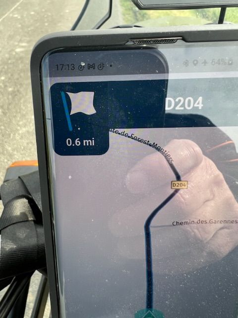
I don’t think I have ever see it before? I thought it might show that the end point of the route was not far away. But it wasn’t; the end of the route was still about 20 miles away.
Thanks,
Richard
-
With my iPhone and MRA Navigation Next I had the same ‘problem’ with the recording of the track in that it sometimes (not always) was ahead of the position of my motorbike.
And I also saw a white flag twice and didn’t understand that either. They were no via-point or endpoints.
-
On an Samsung S10, in off-line mode, using the downloaded maps.
First the good news, it behaved pretty well for 186 miles on D roads in northern France.
I was running a Garmin XT at the same time, running exactly the same route, which I had created in RouteLab, exporting (sharing) in version 1.2, via Garmin Drive.
The few problems were:
- The position cursor lagged behind the bike’s position by somewhere between 50 and 100 metres, maybe further.
The odd thing was that the grey line, which shows the track of where the bike has moved along the blue route, was ahead of the position cursor. In other words, the tip or ‘sharp end’ of the grey line was accurate, the cursor’s position was not.
This resulted in the cursor still showing the bike entering a roundabout, after the bike had already left the roundabout. Similarly, because the position cursor was ‘late’ (ie behind the bike’s actual position) it mean that turn instructions would be given after the junction had been passed
The Garmin XT’s position cursor was always accurate.
- Sometimes, not often, the app refused to recognise that I had been through a simple shaping point on the route. It kept on trying to turn me around to go through it.
The XT, running the same route, with identical shaping points did not have the same problem. It knew I had passed through the shaping points correctly.
I checked that the shaping points were placed accurately on the roads and in the correct carriageway. They were all correctly placed.
- I am not sure what this flag means:
I don’t think I have ever see it before? I thought it might show that the end point of the route was not far away. But it wasn’t; the end of the route was still about 20 miles away.
Thanks,
Richard
@Richard-18 Thanks for the feedback!
We are aware of the position delay and this will be improved for sure. Regarding your other points it would help a lot if you could share the route and indicate where the issues occurred:
- which waypoints weren’t checked off on passing?
- where on the route did the flag icon turn up?
Thanks in advance.
-
@Richard-18 Thanks for the feedback!
We are aware of the position delay and this will be improved for sure. Regarding your other points it would help a lot if you could share the route and indicate where the issues occurred:
- which waypoints weren’t checked off on passing?
- where on the route did the flag icon turn up?
Thanks in advance.
Hi Corjan,
I meant to mark the spot where the app was trying to send me back through a shaping point I had passed but it was pouring with rain so I pressed on. I had the same problem today, once in about 160 miles, but again it was pouring with rain.
I can identify where I saw the strange flag. It appeared before the spot in the picture but quite where it started exactly or why, I don’t know. This was where I took the picture,
The route I was riding was;
https://www.myrouteapp.com/en/social/route/7296135?mode=share
I would guess (but it really is a guess) that the strange flag appeared at or before shaping point 61. I have never seen the flag before and I have not seen it since.
The flag was visible for at least 10 minutes, probably longer. Then it suddenly vanished.
-
Strange thing on today’s route back to Calais.
Again, I am running the beta app on my S10 phone and my XT together, both running an identical route, created in Route Lab.
The estimated distance and estimated time given by the app and by the XT were very nearly identical, much as you would expect. I am never fussy if the two do not match exactly. The remaining time and remaining distance figures reduced, near enough evenly between the app and the XT, exactly as you would expect they would.
Suddenly, for no reason that I could see, the app gave an estimated distance remaining that was at least 40 miles less than that shown on the XT. But the app still showed a matching remaining time of travel. I think the XT correctly showed 120 miles remaining, but the app suddenly showed something like 80 miles remaining.
The app kept showing the very different remaining mileage, counting down. I would guess it did this for at least 20 miles. Then suddenly, everything matched again. I have never seen this strange thing before or since.
All the best,
Richard
-
Hi Corjan,
I meant to mark the spot where the app was trying to send me back through a shaping point I had passed but it was pouring with rain so I pressed on. I had the same problem today, once in about 160 miles, but again it was pouring with rain.
I can identify where I saw the strange flag. It appeared before the spot in the picture but quite where it started exactly or why, I don’t know. This was where I took the picture,
The route I was riding was;
https://www.myrouteapp.com/en/social/route/7296135?mode=share
I would guess (but it really is a guess) that the strange flag appeared at or before shaping point 61. I have never seen the flag before and I have not seen it since.
The flag was visible for at least 10 minutes, probably longer. Then it suddenly vanished.
@Richard-18 thanks! This helps
")
Hello! It looks like you're interested in this conversation, but you don't have an account yet.
Getting fed up of having to scroll through the same posts each visit? When you register for an account, you'll always come back to exactly where you were before, and choose to be notified of new replies (either via email, or push notification). You'll also be able to save bookmarks and upvote posts to show your appreciation to other community members.
With your input, this post could be even better 💗
Register Login-
-320368
-
0547
-
0596
-
0355
-
09141
-
0320
-
1225
-
0234