Viewing trackpoints
-
Is there a way in MRA to view all of the individual track points that make a track instead of (or in addition to) just viewing the track line itself?
If not, is there an app or online viewer that anyone can recommend that can do so?
Thanks!
Steve Jarrell
Western North Carolina USLifetime Routeplanner Gold & Navigation Next
2025 BMW R1200GS
2025 Can-Am Spyder
DMD T865-X 8" Tablet
Garmin XT3 -
Is there a way in MRA to view all of the individual track points that make a track instead of (or in addition to) just viewing the track line itself?
If not, is there an app or online viewer that anyone can recommend that can do so?
Thanks!
@Steve-Jarrell no, that's not possible.
I use a GPX viewer on the internet when debugging individual gpx files.
All the thousands of individual coordinates are rarely of any interest. -
@Steve-Jarrell no, that's not possible.
I use a GPX viewer on the internet when debugging individual gpx files.
All the thousands of individual coordinates are rarely of any interest.@Corjan-Meijerink I totally agree that it's rarely useful and that it's definitely not needed in MRA, but I'm just the curious type! What online viewer do you use?
Thanks!
Steve
Steve Jarrell
Western North Carolina USLifetime Routeplanner Gold & Navigation Next
2025 BMW R1200GS
2025 Can-Am Spyder
DMD T865-X 8" Tablet
Garmin XT3 -
@Corjan-Meijerink I totally agree that it's rarely useful and that it's definitely not needed in MRA, but I'm just the curious type! What online viewer do you use?
Thanks!
Steve
@Steve-Jarrell gpsvisualizer or gpx.studio
-
@Steve-Jarrell gpsvisualizer or gpx.studio
@Corjan-Meijerink I looked at those but I didn't initially see a way to view the actual track points. I'll go back and figure it out!
")
Thanks!
Steve
-
I use GPS track editor, take a look on this site:: http://www.gpstrackeditor.com/
-
I use GPS track editor, take a look on this site:: http://www.gpstrackeditor.com/
@Bert-Mulder Will do. Thanks!
-
Here's what I finally did that works extremely well for me. As I said in another post I simply wanted to see all of the exact GPS points in a .gpx file that comprise a track overlaid on a map. I found an even better solution than what I was originally looking for using the Google Earth Pro app (free) and Gpsvisualizer.com (also free except for the donation I made).
-
Download and install a free copy of Google Earth Pro. You could use the web browser version, but according to an email from Adam Schneider (creator of the gpsvisualizer.com website and utilities) if you have a thousand or more gps point it can overload your browser.
-
Go to to the "Convert your data for use in Google Earth" page in gpsvisualizer.com.
-
Upload your .gpx file using the "Upload your .gpx data files" option on the right side of the page, then under "Track Options" select "Yes, with no names", then under "Waypoint Options" select "Default Icon" and select how you want your GPS points to be drawn (I chose small circles".
-
Select "Create KML file" and a .kmz file will be created that you can then download on your computer.
-
When you click on the downloaded .kmz file the Google Earth app will open automatically and the track will be displayed with all of the GPS point. It will look something like this:
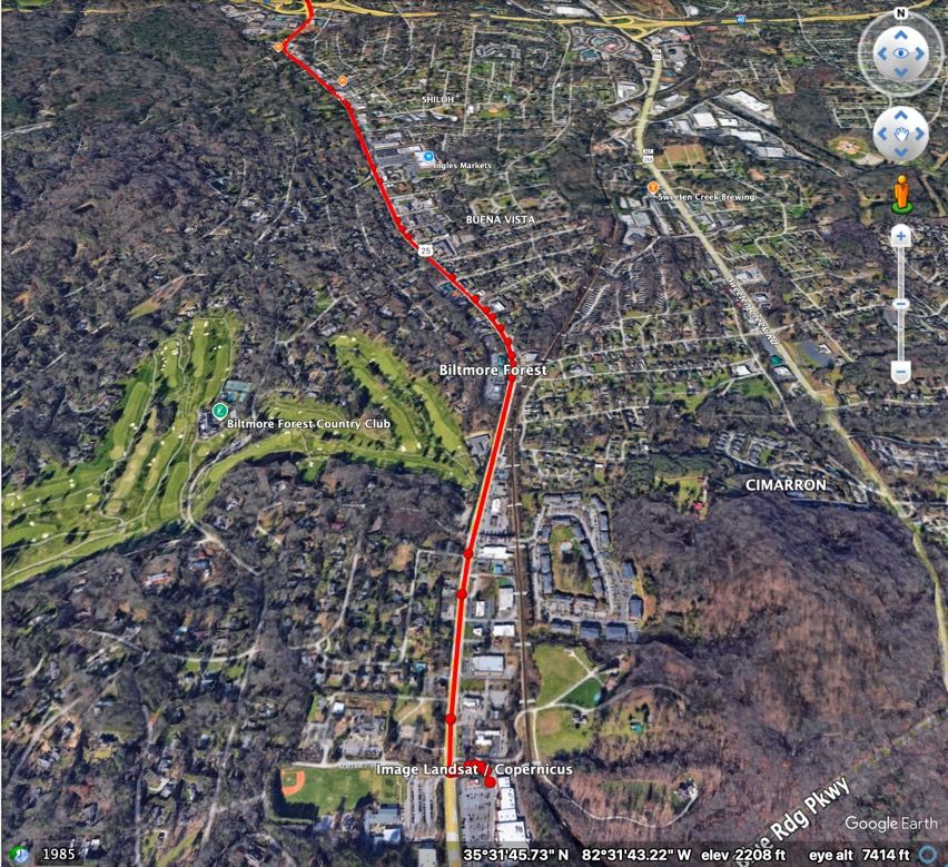
You can zoom in and out right down to the street level, and you can also move around 360 degrees to view the track and points from any angle.
I know this information will be useless to most people as everyone basically just wants to see the finished track, but if you are curious here's how to view your gpx file tracks individual gps points!
-
Hello! It looks like you're interested in this conversation, but you don't have an account yet.
Getting fed up of having to scroll through the same posts each visit? When you register for an account, you'll always come back to exactly where you were before, and choose to be notified of new replies (either via email, or push notification). You'll also be able to save bookmarks and upvote posts to show your appreciation to other community members.
With your input, this post could be even better 💗
Register Login-
1936.3k
-
0466
-
014215
-
0253
-
17438.7k
-
255613.0k
-
0948
-
04119