BMW Connected Ride Navigator not importing waypoints
-
@Hans-van-de-Ven-MR-MRA !
I'm not saying it doesn't work, but it just seems very strange to need these workarounds when previously technology has worked fine.
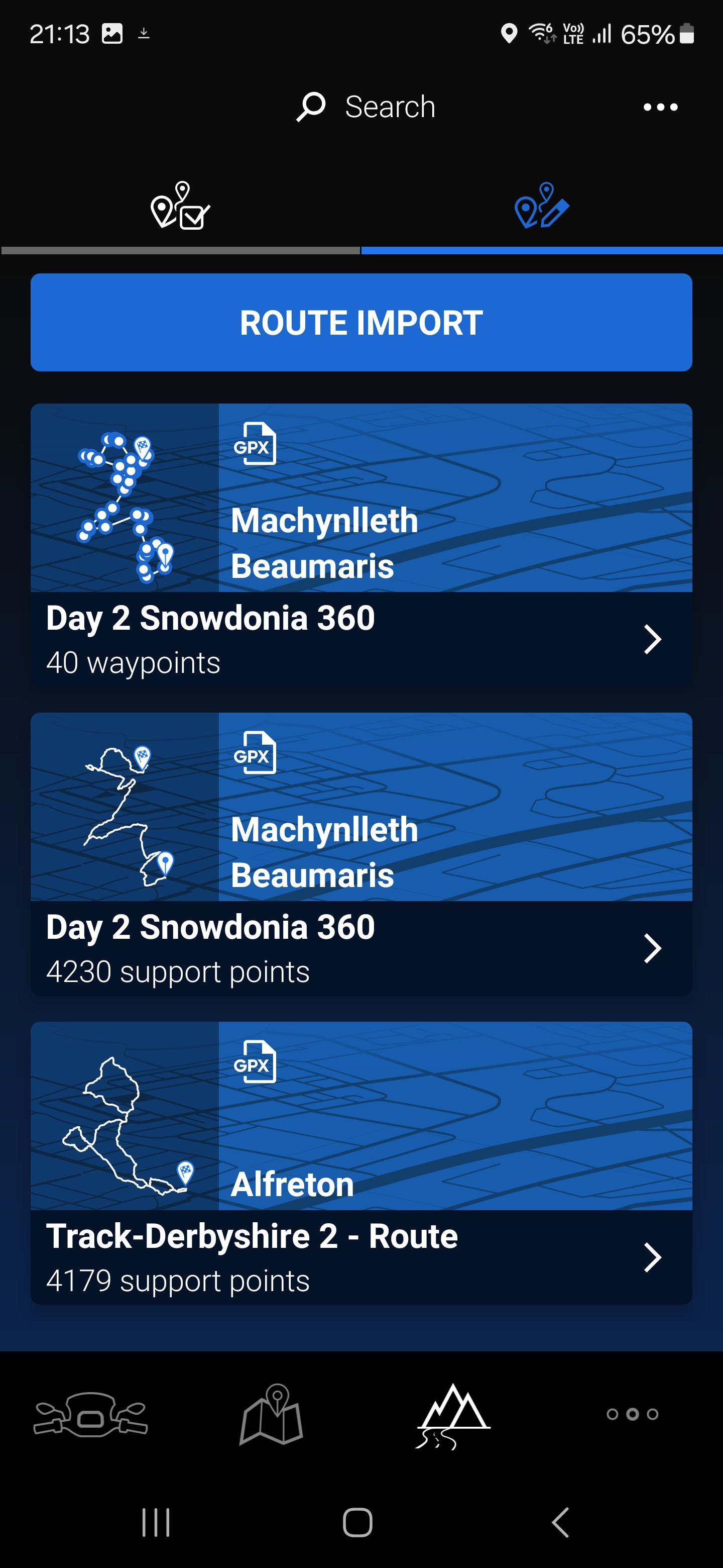
The top route is a gpx file showing a route made in Basecamp. As you can see it has the waypoints already set up as per the gpx file created. This can be imported directly into the CRN.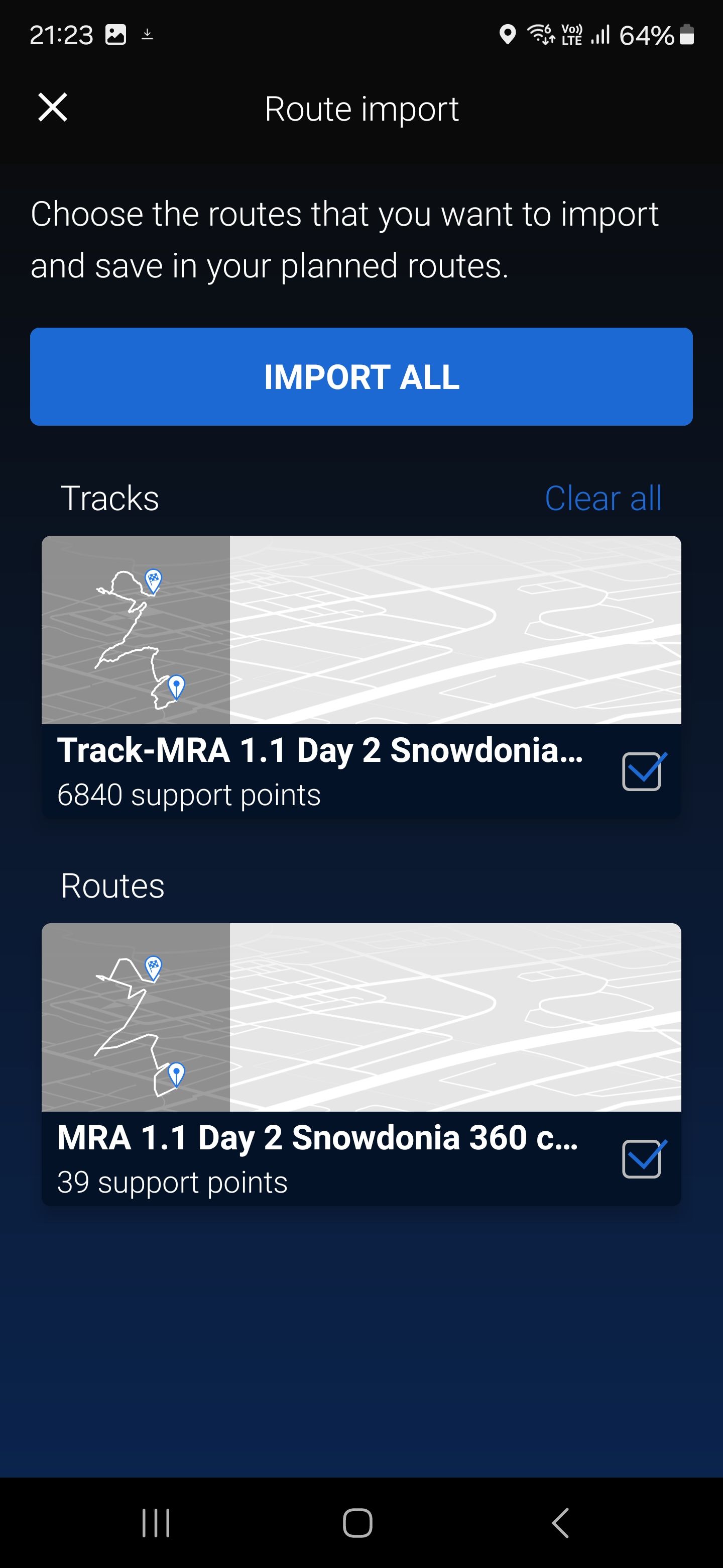
This shows the same route created in MRA and exported as GPX 1.1
As you can see the CRA shows them as support points and as you have explained, the route has to be converted to waypoints in the app, you then have to export this to the CRN (because you don't have the option to convert in the CRN. )Other points to note are that, unlike our previous NAV5, there isn't the option to "fix" your route. Therefore, if you're like us and ride to planned routes (either from mags or ones we've created) we have to add more waypoints than previously added because it doesn't recognise shaping points and is more likely to take you off your route. We have to add them in after junctions so that it sticks to the route as much as possible, but then if needed we can skip them due to traffic/road closure etc. Therefore, the 50 max waypoints doesn't help and we have to break up our tours into smaller chunks. I understand this isn't an MRA issue and hopefully the CRN will provide further updates from everyone's feedback as it's still relatively new.
As I say it's not impossible, but for us, using Basecamp and the NAV5 was straight forward to plan, export and ride our routes compared to MRA/CRA/CRN set up.
@Topcat502
Different technology.
BMW Nav 5 and Basecamp = Garmin
BMW Connected App and the CRN = TomTomGarmin Zumo XT3/XT2/XT/BMW Connected Ride Navigator/Tourstart/ MyRouteapp (The App)/...
Een dag niet gelachen is een dag niet geleefd / Een route is net zo goed als deze uitgezet is. -
A further update to this
We've now done a ride where we have converted to waypoints through the Connected Ride App and then used the CRN to navigate. It doesn't recognise the difference between a destination and a waypoint, as the navigation display shows ETA for the next waypoint and the destination as the same. It also removes the waypoint from the route on the map as you go along. It doesn't alert you to the name of the waypoint either, it just tells you (sometimes) that you have reached your destination. -
@Topcat502
Different technology.
BMW Nav 5 and Basecamp = Garmin
BMW Connected App and the CRN = TomTom@Hans-van-de-Ven-MR-MRA
Hi just started withn this ConnectedRide Navigator.
Question 1) Do i have to use TOMTOM Maps as default to export the GPX 1.1 file so it's recognised accurately in Navigator or does it not matter?
I have created both the track and Route files to test with HERE Maps and the TOMTOM Maps- not sure what is going to work here.
Question 2) Should i just create the Routes with the maximum 50 Shaping points and use that in GPX 1.1 format? either TOMTOM or HERE Maps (what works)?
Question 3) I preume if a track is too large it just can't handle it. Had a error when testing.
Hope they update so we can see the detail of way points, as that's most dissapointing.
Regards
Jez
-
@Hans-van-de-Ven-MR-MRA
Hi just started withn this ConnectedRide Navigator.
Question 1) Do i have to use TOMTOM Maps as default to export the GPX 1.1 file so it's recognised accurately in Navigator or does it not matter?
I have created both the track and Route files to test with HERE Maps and the TOMTOM Maps- not sure what is going to work here.
Question 2) Should i just create the Routes with the maximum 50 Shaping points and use that in GPX 1.1 format? either TOMTOM or HERE Maps (what works)?
Question 3) I preume if a track is too large it just can't handle it. Had a error when testing.
Hope they update so we can see the detail of way points, as that's most dissapointing.
Regards
Jez
Hello
-
Yes, it is best to use the TomTom card, because the CRN also uses the TomTom card. And the GPX 1.1 file also gives the best result and you can make the Shaping points visible in the connected app and therefore also on the CRN. There are no formation points in a GPX 1.2.
-
You can create more than 50 Shaping points, only the connected app can make a maximum of 50 visible.
-
If you have more than 50 Shaping points in your route, take the track, this is the file with more than 3000 support points.
Garmin Zumo XT3/XT2/XT/BMW Connected Ride Navigator/Tourstart/ MyRouteapp (The App)/...
Een dag niet gelachen is een dag niet geleefd / Een route is net zo goed als deze uitgezet is. -
-
Hello
-
Yes, it is best to use the TomTom card, because the CRN also uses the TomTom card. And the GPX 1.1 file also gives the best result and you can make the Shaping points visible in the connected app and therefore also on the CRN. There are no formation points in a GPX 1.2.
-
You can create more than 50 Shaping points, only the connected app can make a maximum of 50 visible.
-
If you have more than 50 Shaping points in your route, take the track, this is the file with more than 3000 support points.
@Hans-van-de-Ven-MR-MRA
Many thanks i will try that.
Do you think we will eventually be able to obtain the information as per way points in MRA Navigation. Or at least some way to communicate the notes for each way point like Fuel - Coffee stop etc.
Regards
Jez
-
-
@Hans-van-de-Ven-MR-MRA
Many thanks i will try that.
Do you think we will eventually be able to obtain the information as per way points in MRA Navigation. Or at least some way to communicate the notes for each way point like Fuel - Coffee stop etc.
Regards
Jez
No, I don't think so, because TomTom has to change this
Garmin Zumo XT3/XT2/XT/BMW Connected Ride Navigator/Tourstart/ MyRouteapp (The App)/...
Een dag niet gelachen is een dag niet geleefd / Een route is net zo goed als deze uitgezet is. -
No, I don't think so, because TomTom has to change this
@Hans-van-de-Ven-MR-MRA
Hi,
On another note when we look at routes could you add a field so we can see what mapping we used to create; either TOMTOM or HERE Maps.
Save me having to open all the routes.
-
@Hans-van-de-Ven-MR-MRA
Hi,
On another note when we look at routes could you add a field so we can see what mapping we used to create; either TOMTOM or HERE Maps.
Save me having to open all the routes.
When you create a route you can choose the map
Garmin Zumo XT3/XT2/XT/BMW Connected Ride Navigator/Tourstart/ MyRouteapp (The App)/...
Een dag niet gelachen is een dag niet geleefd / Een route is net zo goed als deze uitgezet is. -
When you create a route you can choose the map
@Hans-van-de-Ven-MR-MRA
Hi,
Yes i know that - but if i am planning for TOMTOM or HERE Maps it be good to see what system i used in the information. Maybe we could add other details like avoidances used and if road closures are ignored etc.
Only other way but without all that detail would be to create seperate folders fot HERE and TOMTOM but missing the information in that box that would be nice.
Regards
Jez
-
Use the TomTom map, use max 50 shaping points. Then send it to the connected app, choose the track and route with 50 points.
Then in the route file tick on the 3 dots in the upper right corner and choose convert to route with points. The 50 points will be visible.
Choose that route on the CRN and you can also make the track visible on the CRN@Hans-van-de-Ven-MR-MRA yes correct. I just uploaded a topic on the same issue, did not know you had already posted this here. Is the 50 points a Tom Tom limit or is it just the Connected Ride app the limiting factor?
-
@Hans-van-de-Ven-MR-MRA yes correct. I just uploaded a topic on the same issue, did not know you had already posted this here. Is the 50 points a Tom Tom limit or is it just the Connected Ride app the limiting factor?
Maybe BMW should have collaborated with MRA - i have now had some correspondence with them with a list of improvements that could be made.
Only option at present is possibly the Carpe Iter. Then I can use MRA for Navigation and the Tablet allows far greater use.
Hello! It looks like you're interested in this conversation, but you don't have an account yet.
Getting fed up of having to scroll through the same posts each visit? When you register for an account, you'll always come back to exactly where you were before, and choose to be notified of new replies (either via email, or push notification). You'll also be able to save bookmarks and upvote posts to show your appreciation to other community members.
With your input, this post could be even better 💗
Register Login-
017269
-
110132
-
0447
-
17410
-
012337
-
06278
-
015445
-
0274