Pass a shaping point, GPS stop follow road
-
My first day with Beta Navigation. Had an issue I had not seen with pre-Beta Navigation app.
This simple route was created on MRA Website. Point "2" was created by dragging the route away from the freeway, creating the teardrop shaping point.
HERE map default.
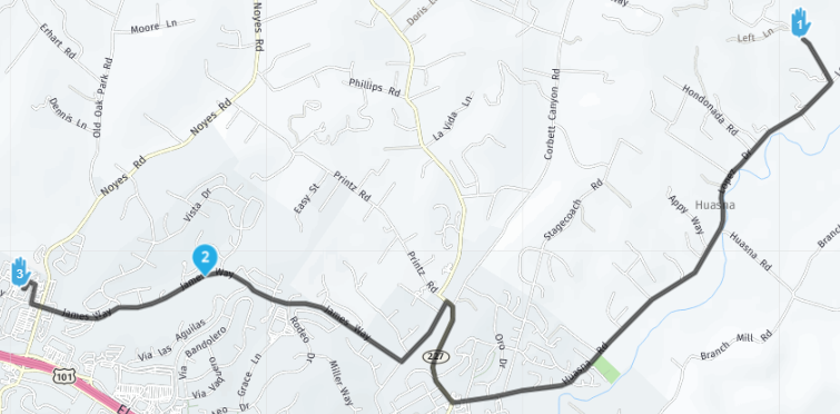
When I traveled past the shaping point, the GPS no longer followed the road and kept going straight ahead.
Then there was an app message regarding the waypoint - I couldn't capture it as I was on motorcycle - I think it said something about passing a point. I did not touch anything, and after about 15 seconds the route continued OK.
I have seen the video on shaping points / Via points. This point was not a "hand" and seems it should not have been concerned if I missed it.
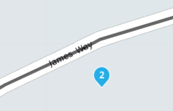
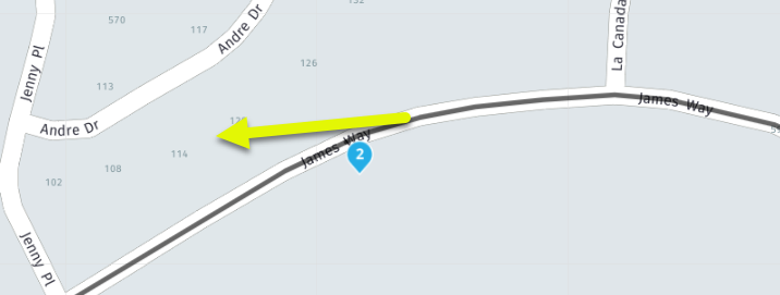
When I got home I zoomed in to see if the shaping point was incorrectly placed, and it was a bit off the road. But the route correctly snapped to the road and there was no cross street at the shaping point.
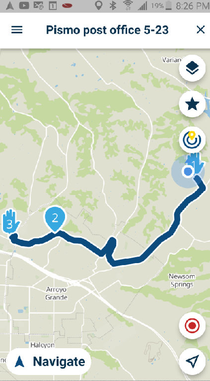
This is how it looked on the Beta App, running on Android set to offline
-
My first day with Beta Navigation. Had an issue I had not seen with pre-Beta Navigation app.
This simple route was created on MRA Website. Point "2" was created by dragging the route away from the freeway, creating the teardrop shaping point.
HERE map default.

When I traveled past the shaping point, the GPS no longer followed the road and kept going straight ahead.
Then there was an app message regarding the waypoint - I couldn't capture it as I was on motorcycle - I think it said something about passing a point. I did not touch anything, and after about 15 seconds the route continued OK.
I have seen the video on shaping points / Via points. This point was not a "hand" and seems it should not have been concerned if I missed it.
When I got home I zoomed in to see if the shaping point was incorrectly placed, and it was a bit off the road. But the route correctly snapped to the road and there was no cross street at the shaping point.

This is how it looked on the Beta App, running on Android set to offline

@Bob-Harvey, That looks like normal and to be expected behavior. Your waypoint is not on the road, and at enough distance to not "hit" it while passing. The Auto-skip feature detects that you missed and are travelling towards the next waypoint. It throws a message on which you can tap to NOT skip if you don't want that. You did not tap it, so Next is continuing to waypoint 3. Perfect!

The only curious thing is that:
When I traveled past the shaping point, the GPS no longer followed the road and kept going straight ahead.
You don't happen to have the tracklog do you? I don't think it is related to the WP. Sounds more like a temporary bad GPS signal or something. It would be great to know if it's reproducible.
-
@Bob-Harvey, That looks like normal and to be expected behavior. Your waypoint is not on the road, and at enough distance to not "hit" it while passing. The Auto-skip feature detects that you missed and are travelling towards the next waypoint. It throws a message on which you can tap to NOT skip if you don't want that. You did not tap it, so Next is continuing to waypoint 3. Perfect!

The only curious thing is that:
When I traveled past the shaping point, the GPS no longer followed the road and kept going straight ahead.
You don't happen to have the tracklog do you? I don't think it is related to the WP. Sounds more like a temporary bad GPS signal or something. It would be great to know if it's reproducible.
That looks like normal and to be expected behavior. Your waypoint is not on the road, and at enough distance to not "hit" it while passing.
A slight aside: I have always wondered how close to the 'correct route' does the shaping point have to be to not be ignored?
Is it a specific number of metres from the road, or some clever algorithm depending on what else is around (like other roads/points of interest)?
It's odd (to a user) that the routing software knows the route that matches an inaccurately placed waypoint, but the live navigation doesn't. I guess the live navigation is making allowance for genuine waypoints not on a public road.
-
That looks like normal and to be expected behavior. Your waypoint is not on the road, and at enough distance to not "hit" it while passing.
A slight aside: I have always wondered how close to the 'correct route' does the shaping point have to be to not be ignored?
Is it a specific number of metres from the road, or some clever algorithm depending on what else is around (like other roads/points of interest)?
It's odd (to a user) that the routing software knows the route that matches an inaccurately placed waypoint, but the live navigation doesn't. I guess the live navigation is making allowance for genuine waypoints not on a public road.
@richtea-0, good question, I have no idea

Maybe @Corjan-Meijerink can enlighten us. -
@Bob-Harvey, That looks like normal and to be expected behavior. Your waypoint is not on the road, and at enough distance to not "hit" it while passing. The Auto-skip feature detects that you missed and are travelling towards the next waypoint. It throws a message on which you can tap to NOT skip if you don't want that. You did not tap it, so Next is continuing to waypoint 3. Perfect!

The only curious thing is that:
When I traveled past the shaping point, the GPS no longer followed the road and kept going straight ahead.
You don't happen to have the tracklog do you? I don't think it is related to the WP. Sounds more like a temporary bad GPS signal or something. It would be great to know if it's reproducible.
@Con-Hennekens said in Pass a shaping point, GPS stop follow road:
You don't happen to have the tracklog do you?
No - I will try driving the route again with tracking.
This is what I saw as I was on my motorcycle. The GPS was showing me continue straight but I was actually traveling on the road.
My setting was default, to skip waypoints automatically
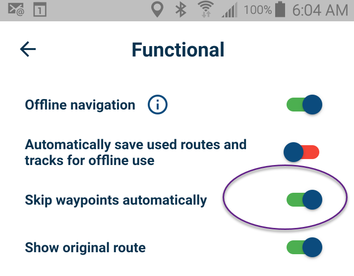
It correctly skipped the waypoint - but that was after alerting me and asking me.
In Serge video he also uses the term "via point" (hand) that you cannot skip and I understand that.
Although I am new to MRA and as a Newbie I am garbage... I may have some use because I have background using GPS for over 20 years and have suffered with BaseCamp.
I think many motorcycle riders want to use MRA because the Garmin software is so terrible. So many potential customers are coming from Garmin background.
Garmin will punish you severely if you pass a point that is not EXACTLY on the road, and make you do U-turns unless you have done 100 hours of tutorials that explain how to do this

Essentially you want to select everything other than the start point, and the destination. You don't want the GPS to do U-turns, you just want to ride the motorcycle.
That is one of the things that really attracted me to MRA, on the website I could start a route, click along the twisted path I wanted to take, and automatically the points other than START and END were shaping points (teardrops - not hands). It was such a relief, and usually worked great if I placed the points fairly close to the road.Before my recent purchase of Gold and Navigation Next Beta, I had this experience with MRA where a waypoint was off the road and there happened to be a short road in that region
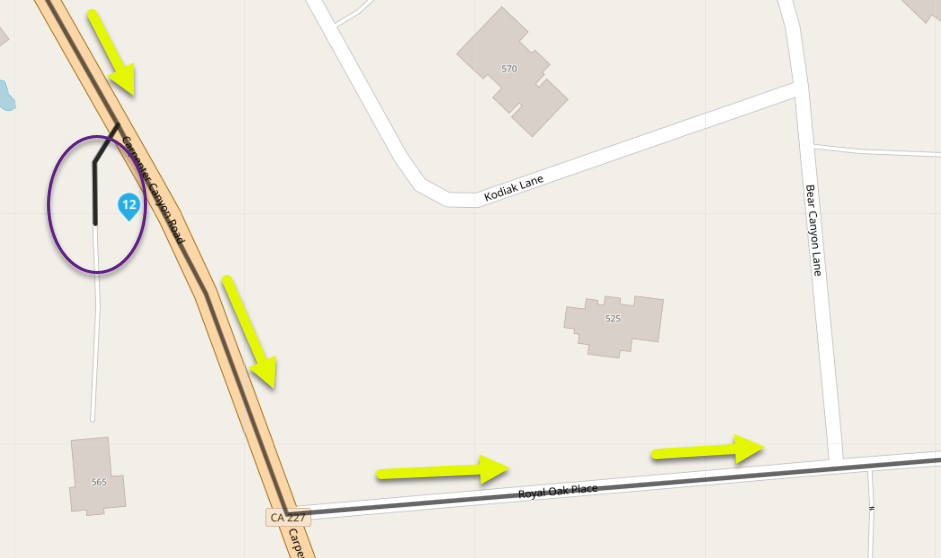
As I was riding my motorcycle I could see the MRA Navigation app (original app) wanted me to turn right on a road I did not intend. I kept riding straight, and the app behaved very well, saw that I passed the shaping point and let me continue on my ride. I did not touch the screen to select yes or no on passing the point and it let me keep going after a while.
That is a huge improvement over what Garmin software and Garmin devices would have done (unless I had the 100 hours of study to know to create a non-alerting shaping point using the abandoned BaseCamp software).
As a new user experiencing the Beta App interface, my only complaint is the User Interface to access SETTINGS. I realize that the 3 dots opens a menu for common settings, such as skip waypoints. My issue as a new user in United States was changing Kilometers to Miles on the Navigation app.
As a new user, I open a route in Navigation Next Beta
I touch the 3 bars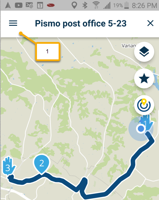
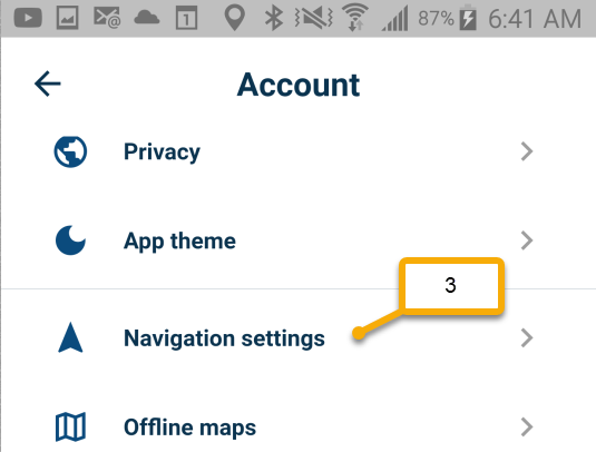
I actually searched for 5 minutes to find "settings" and eventually touched the icon (2)
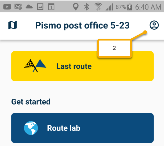
Then (3)
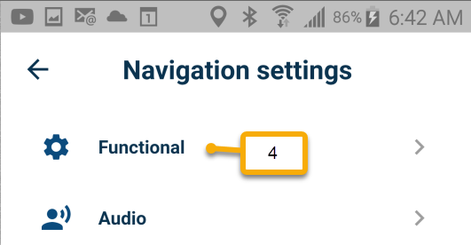
Then (4)
to get to (5)
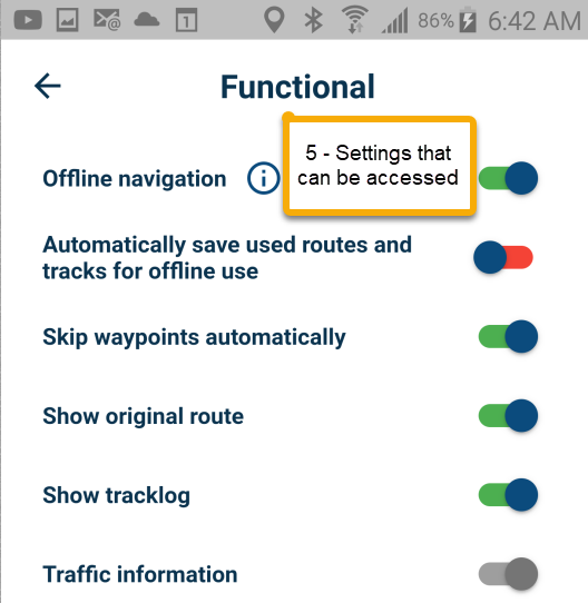
I was not able to change Kilometers to Miles here - but discovered that setting on the main MRA website for my account.
That setting may have changed when I recently purchased Gold because I thought I had selected "Miles" last week, but it was back to the default Metric setting.
Maybe there could be a choice there for "more settings" in the 3 dot navigation screen that takes you to "Functional" on your profile.
-
@Con-Hennekens said in Pass a shaping point, GPS stop follow road:
You don't happen to have the tracklog do you?
No - I will try driving the route again with tracking.
This is what I saw as I was on my motorcycle. The GPS was showing me continue straight but I was actually traveling on the road.

My setting was default, to skip waypoints automatically

It correctly skipped the waypoint - but that was after alerting me and asking me.
In Serge video he also uses the term "via point" (hand) that you cannot skip and I understand that.
Although I am new to MRA and as a Newbie I am garbage... I may have some use because I have background using GPS for over 20 years and have suffered with BaseCamp.
I think many motorcycle riders want to use MRA because the Garmin software is so terrible. So many potential customers are coming from Garmin background.
Garmin will punish you severely if you pass a point that is not EXACTLY on the road, and make you do U-turns unless you have done 100 hours of tutorials that explain how to do this

Essentially you want to select everything other than the start point, and the destination. You don't want the GPS to do U-turns, you just want to ride the motorcycle.
That is one of the things that really attracted me to MRA, on the website I could start a route, click along the twisted path I wanted to take, and automatically the points other than START and END were shaping points (teardrops - not hands). It was such a relief, and usually worked great if I placed the points fairly close to the road.Before my recent purchase of Gold and Navigation Next Beta, I had this experience with MRA where a waypoint was off the road and there happened to be a short road in that region

As I was riding my motorcycle I could see the MRA Navigation app (original app) wanted me to turn right on a road I did not intend. I kept riding straight, and the app behaved very well, saw that I passed the shaping point and let me continue on my ride. I did not touch the screen to select yes or no on passing the point and it let me keep going after a while.
That is a huge improvement over what Garmin software and Garmin devices would have done (unless I had the 100 hours of study to know to create a non-alerting shaping point using the abandoned BaseCamp software).
As a new user experiencing the Beta App interface, my only complaint is the User Interface to access SETTINGS. I realize that the 3 dots opens a menu for common settings, such as skip waypoints. My issue as a new user in United States was changing Kilometers to Miles on the Navigation app.
As a new user, I open a route in Navigation Next Beta
I touch the 3 bars
I actually searched for 5 minutes to find "settings" and eventually touched the icon (2)

Then (3)

Then (4)

to get to (5)

I was not able to change Kilometers to Miles here - but discovered that setting on the main MRA website for my account.
That setting may have changed when I recently purchased Gold because I thought I had selected "Miles" last week, but it was back to the default Metric setting.
Maybe there could be a choice there for "more settings" in the 3 dot navigation screen that takes you to "Functional" on your profile.
@Bob-Harvey, I share your "difficulties" with Basecamp. But that was already some time ago. I created my MRA account back in 2017 and never looked at basecamp again. in februari 2018 I subscribed to Navigation, and never looked at my Zumo again

I understand it takes some getting used to, like with every new software. But I can tell that MRA is enhancing the Mobile app very quickly.
-
I think navigation should automatically switch between miles & kilometers based on the country being traveled. From Canada traveling into the US and then back to Canada should not require me going to my online account to make the change.
-
I think navigation should automatically switch between miles & kilometers based on the country being traveled. From Canada traveling into the US and then back to Canada should not require me going to my online account to make the change.
@Doug-Robinson said in Pass a shaping point, GPS stop follow road:
I think navigation should automatically switch between miles & kilometers based on the country being traveled.
Agreed.
It should do this automatically unless overridden in the settings.That's probably the path of least resistance, so to speak, for the majority of users.
-
 undefined Bob Harvey referenced this topic on
-
@Bob-Harvey, That looks like normal and to be expected behavior. Your waypoint is not on the road, and at enough distance to not "hit" it while passing. The Auto-skip feature detects that you missed and are travelling towards the next waypoint. It throws a message on which you can tap to NOT skip if you don't want that. You did not tap it, so Next is continuing to waypoint 3. Perfect!

The only curious thing is that:
When I traveled past the shaping point, the GPS no longer followed the road and kept going straight ahead.
You don't happen to have the tracklog do you? I don't think it is related to the WP. Sounds more like a temporary bad GPS signal or something. It would be great to know if it's reproducible.
@Con-Hennekens said in Pass a shaping point, GPS stop follow road:
You don't happen to have the tracklog do you?
I did not record a tracklog yesterday.
I just did the same ride, same Android phone following same route and there were no issues. The GPS followed the road, and there was no "alert" that a shaping point was missed.
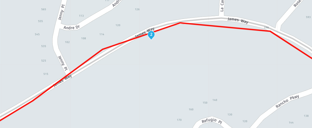
I did record a tracklog today, but there was no issues. The darker line is the tracklog, the lighter one is the route
I created a separate post on the number of clicks to change Metric measurements to Miles, it was my mistake to discuss 2 things.
I don't know why my navigation was odd yesterday, and unable to reproduce it today. I do know that the 2 times I have used the Beta Navigation Next the loading of the map, as well as traveling on the route appear sluggish (slow) compared to the original MRA Navigation app.
-
@Con-Hennekens said in Pass a shaping point, GPS stop follow road:
You don't happen to have the tracklog do you?
I did not record a tracklog yesterday.
I just did the same ride, same Android phone following same route and there were no issues. The GPS followed the road, and there was no "alert" that a shaping point was missed.
I did record a tracklog today, but there was no issues. The darker line is the tracklog, the lighter one is the route

I created a separate post on the number of clicks to change Metric measurements to Miles, it was my mistake to discuss 2 things.
I don't know why my navigation was odd yesterday, and unable to reproduce it today. I do know that the 2 times I have used the Beta Navigation Next the loading of the map, as well as traveling on the route appear sluggish (slow) compared to the original MRA Navigation app.
@Bob-Harvey, I have not heard of sluggish in the sense of slow loading maps yet, and do not share the experience. But what could help out is downloading the maps of your area for off-line use. That prevents the map from being downloaded on the go.
We all do know about sluggish, in the sense that the on-screen position lags. That is something that is being worked on
