How to make satnav flag up my coffee stops?
-
I have a BMW Nav V (ie Garmin) GPS, and use it with GPX v1.1 files downloaded from MRA. So I use shaping points to define the overall routes, with waypoints set at fixed points where I want to stop, eg for coffee or meal breaks.
My question - how do I persuade the GPS to display some useful info about the waypoints? Like, their name, or the distance to them? Right now I get nothing, and it's quite common for me to ride straight past waypoints where I'd earmarked a stop. I feel sure I must be doing something wrong?
@David-P-0
I'm afraid that won't work with MRA planner.
When I still had a Garmin I used Garmin POI Loader for that.
But that's actually quite a lot of work. -
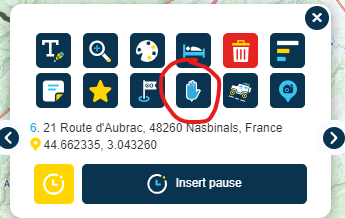
@David-P-0 would it work if you convert the shaping point into a via point? You can toggle any route waypoint between these two sub-types by clicking the icon in the waypoint menu (see below, it's the hand icon on the second row of icons in the menu).

If you create it as a via point (where the point is displayed on the map with a hand icon not a "guitar pick" icon), you can configure the Garmin to display distance/time to next and get alerts on arrival.
-
I have a BMW Nav V (ie Garmin) GPS, and use it with GPX v1.1 files downloaded from MRA. So I use shaping points to define the overall routes, with waypoints set at fixed points where I want to stop, eg for coffee or meal breaks.
My question - how do I persuade the GPS to display some useful info about the waypoints? Like, their name, or the distance to them? Right now I get nothing, and it's quite common for me to ride straight past waypoints where I'd earmarked a stop. I feel sure I must be doing something wrong?
@David-P-0
hij have the same Nation V and always urs the GPX 1.2 format for the simple reason that I then only see (all The) via points and no shaping points. -
@David-P-0
I'm afraid that won't work with MRA planner.
When I still had a Garmin I used Garmin POI Loader for that.
But that's actually quite a lot of work.@Jack-van-Tilburg
It does work Including the names of the via points that you use in MyRoute App. You have to use the GPX for at for that.
 -
@David-P-0 would it work if you convert the shaping point into a via point? You can toggle any route waypoint between these two sub-types by clicking the icon in the waypoint menu (see below, it's the hand icon on the second row of icons in the menu).

If you create it as a via point (where the point is displayed on the map with a hand icon not a "guitar pick" icon), you can configure the Garmin to display distance/time to next and get alerts on arrival.
In addition you can give the via point a name with the upper left icon in the screendump above.
