BMW Connected App / MRA question
-
Dear all, could I ask people, with experience of using the BMW connected app with preplanned routes from the MRA app, a question?
If I download a route to my phone and try to follow it on my 1250RT using the TFT display it is easy to follow with the directions. However, my question is this: If I come off the route, for coffee or by mistake for example, what does the app do? Does it direct me back to the route? Or does it replan a route direct to the end point by the fastest route thus ignoring the pre-planned roads that I spent time planning on the MRA app. I can't seem to get an answer and would be very grateful for any help with the answer. Thank you.
@Mike-Denning
If you deviate from the route, the Connected App will continue to recalculate to bring you back on the route.
But my best experience after a break, that is not on the route, is to restart the route and then choose the option: "Direct route".
The app will take you to the nearest point on the route.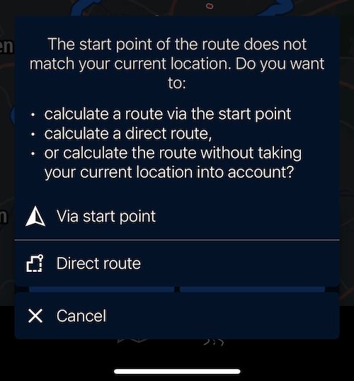
-
Thanks Jack, that's really helpful. Thanks for your time - I will have a try of that and see how it goes. Your answer makes perfect sense to me!
-
Dear all, could I ask people, with experience of using the BMW connected app with preplanned routes from the MRA app, a question?
If I download a route to my phone and try to follow it on my 1250RT using the TFT display it is easy to follow with the directions. However, my question is this: If I come off the route, for coffee or by mistake for example, what does the app do? Does it direct me back to the route? Or does it replan a route direct to the end point by the fastest route thus ignoring the pre-planned roads that I spent time planning on the MRA app. I can't seem to get an answer and would be very grateful for any help with the answer. Thank you.
@Mike-Denning
I also ride a R1250RT with the TFT-screen and the Connected App.
When I deviate from the route, the navigation starts recalculating.
Initially the navigation tries to direct me to the next point I was driving to when I started to wander of course.
When the software notices that I ignore the directions for too long, it will start suggesting a route to the next support and/or waypoint in the route. It has never ignored the route and sent me to the end immediately.
Personally I always zoom out the moment I deviate to see a bigger part of the route. This makes it easier for me to find an appropriate way to get back on the route where I want. -
My wife used it for the first time this weekend. We did 3 days at approximately 200 miles per day.
She’s not overly enamoured with it, having been a Garmin/BMW Nav user for many years.
This biggest issue was the lack of support for shaping and via points and the inability to skip via points that comes with this lack of functionality.
You effectively get to follow the route you planned, but have no information on any intermediate stopovers you have in your planned route.
We always use shaping points in our routes, along with via points for things like fuel, lunch and coffee stops. However, we’ll sometimes stop at a place earlier or later than planned depending on how we’re feeling and simply chose to skip the via point. This isn’t so easy with the Connected app as it doesn’t show all the points on the imported route.
You can import a route that you’ve exported as a GPX and convert it to a list of waypoints in the app, but only if there are fewer than 50 points. Also, each point will become a “must visit” via point which has its own frustrations.
-
My wife used it for the first time this weekend. We did 3 days at approximately 200 miles per day.
She’s not overly enamoured with it, having been a Garmin/BMW Nav user for many years.
This biggest issue was the lack of support for shaping and via points and the inability to skip via points that comes with this lack of functionality.
You effectively get to follow the route you planned, but have no information on any intermediate stopovers you have in your planned route.
We always use shaping points in our routes, along with via points for things like fuel, lunch and coffee stops. However, we’ll sometimes stop at a place earlier or later than planned depending on how we’re feeling and simply chose to skip the via point. This isn’t so easy with the Connected app as it doesn’t show all the points on the imported route.
You can import a route that you’ve exported as a GPX and convert it to a list of waypoints in the app, but only if there are fewer than 50 points. Also, each point will become a “must visit” via point which has its own frustrations.
@Dae-0 said in BMW Connected App / MRA question:
My wife used it for the first time this weekend. We did 3 days at approximately 200 miles per day.
She’s not overly enamoured with it, having been a Garmin/BMW Nav user for many years.
...I have used my BMW Navigator V and Basecamp for many years (and I'm still using it for trips with Max) and was forced to start using the Connected App in 2021 when I bought a RT with a TFT screen.
The Connected App is acceptable (not great) to drive from A to B, but it's not good for touristic trips.
I asked BMW Motorrad why they decided to create their own app and not just use Apple Carplay so that every motorcyclist could choose their favorite app for navigation, but I never got an answer...
Nowadays I drive a 2023 RT and the system has improved. However, it is clear that BMW doesn't work like MRA with a large group of testers so the development is very slow. My dealer told me that by autum of 2023 it will be possible to stop automatic recalculation!? BMW drivers who are used to Garmin have been asking this since 2021...
BMW "Blakkietrie" R1250RT (2023)
Mazda "Max" MX5 ND (2016) -
@Dae-0 said in BMW Connected App / MRA question:
My wife used it for the first time this weekend. We did 3 days at approximately 200 miles per day.
She’s not overly enamoured with it, having been a Garmin/BMW Nav user for many years.
...I have used my BMW Navigator V and Basecamp for many years (and I'm still using it for trips with Max) and was forced to start using the Connected App in 2021 when I bought a RT with a TFT screen.
The Connected App is acceptable (not great) to drive from A to B, but it's not good for touristic trips.
I asked BMW Motorrad why they decided to create their own app and not just use Apple Carplay so that every motorcyclist could choose their favorite app for navigation, but I never got an answer...
Nowadays I drive a 2023 RT and the system has improved. However, it is clear that BMW doesn't work like MRA with a large group of testers so the development is very slow. My dealer told me that by autum of 2023 it will be possible to stop automatic recalculation!? BMW drivers who are used to Garmin have been asking this since 2021...BMW uses TomTom technology within the connected-app and the TFT screen.
-
@Dae-0 said in BMW Connected App / MRA question:
My wife used it for the first time this weekend. We did 3 days at approximately 200 miles per day.
She’s not overly enamoured with it, having been a Garmin/BMW Nav user for many years.
...I have used my BMW Navigator V and Basecamp for many years (and I'm still using it for trips with Max) and was forced to start using the Connected App in 2021 when I bought a RT with a TFT screen.
The Connected App is acceptable (not great) to drive from A to B, but it's not good for touristic trips.
I asked BMW Motorrad why they decided to create their own app and not just use Apple Carplay so that every motorcyclist could choose their favorite app for navigation, but I never got an answer...
Nowadays I drive a 2023 RT and the system has improved. However, it is clear that BMW doesn't work like MRA with a large group of testers so the development is very slow. My dealer told me that by autum of 2023 it will be possible to stop automatic recalculation!? BMW drivers who are used to Garmin have been asking this since 2021...We only moved away from the Nav because both of ours failed within a week of each other and were out of warranty. Mine had the ghosting issue and hers completely died.
We didn’t replace them as there’s no way we’d spend that much money on replacing them knowing that they’re prone to failure and already out of date technology.
I went with WunderLINQ and am currently using it with Scenic until Next supports it. I may still stay with Scenic as it has convenient features like shortcuts to pause and skip music with a single touch of the BMW wheel without changing away from the navigation app. I tried CarPlay but it didn’t work for me as I found the touch screen much more inconvenient than using the wheel.
My wife has already decided she doesn’t want to stick with the Connected app and has put her BMW Connected Ride cradle up for sale after only having it 12 days. She’s also going to replace it with a WunderLINQ
-
BMW uses TomTom technology within the connected-app and the TFT screen.
@MTC-Zeilberg said in BMW Connected App / MRA question:
BMW uses TomTom technology within the connected-app and the TFT screen.
Thank you for pointing that out.
I knew that BMW uses TomTom maps; I didn't know that they also use their navigation technology.
Since I've never used TomTom I can't compare it with the BMW navigation. Nevertheless I believe that the BMW application is very simple. No waypoints, no supporting points, no pictures... Just a line to follow and a friendly voice telling me to go left or right...
BMW "Blakkietrie" R1250RT (2023)
Mazda "Max" MX5 ND (2016) -
@MTC-Zeilberg said in BMW Connected App / MRA question:
BMW uses TomTom technology within the connected-app and the TFT screen.
Thank you for pointing that out.
I knew that BMW uses TomTom maps; I didn't know that they also use their navigation technology.
Since I've never used TomTom I can't compare it with the BMW navigation. Nevertheless I believe that the BMW application is very simple. No waypoints, no supporting points, no pictures... Just a line to follow and a friendly voice telling me to go left or right...The Connected app also registers a lot of information about the ride driven.
This way you can see afterwards what the highest speed was, the highest rpm, maximum height, maximum angle of inclination and the G-forces during acceleration and braking. And of course you can link photos to the registration along the way.
It is of no use to you and yet it is nice to talk about it with your buddies in the evening over a beer at the overnight stay
-
Dear all, could I ask people, with experience of using the BMW connected app with preplanned routes from the MRA app, a question?
If I download a route to my phone and try to follow it on my 1250RT using the TFT display it is easy to follow with the directions. However, my question is this: If I come off the route, for coffee or by mistake for example, what does the app do? Does it direct me back to the route? Or does it replan a route direct to the end point by the fastest route thus ignoring the pre-planned roads that I spent time planning on the MRA app. I can't seem to get an answer and would be very grateful for any help with the answer. Thank you.
@Mike-Denning I am a long complainer about the connected app and it's implementation on the 6.5in TFT as fitted to the GS and GSA (I've had one of each). Over time it has got better but was never quite there.
I now have the K1600GT (with 10.25 TFT and map-view of course) and had everything updated a few weeks ago (TFT and app) and I would say the connected app is now 90% there.
Here's my LIMITED experience with the two... (Gold membership will be necessary for all functions)
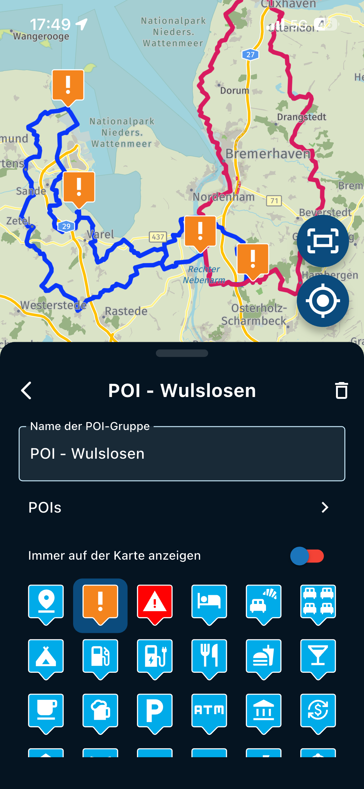
The key I find is to plot a route using Tom-Tom maps (as this is the system the Connected App uses) with 'just' enough Waypoints or Via Points to ensure your route cannot deviate. (Place a waypoint just after a junction for example to ensure the route will go that way). MRA does have a function to add waypoints automatically, but I find that it adds too many, so I either use the 'reduce waypoint' function (where you can then choose how many you want), or just do it yourself. If you use an automated way check they are a) on the actual road, b) placed logically.
Export the file as GPX 1.1 (Route, Track, POI). When importing into the Connected App this will offer you the three parts (Route, Track, POI), deselect for now the Track and POI ones, leaving just the route one. This will have x number of 'support points' that matches the Via and Waypoints in your MRA export.
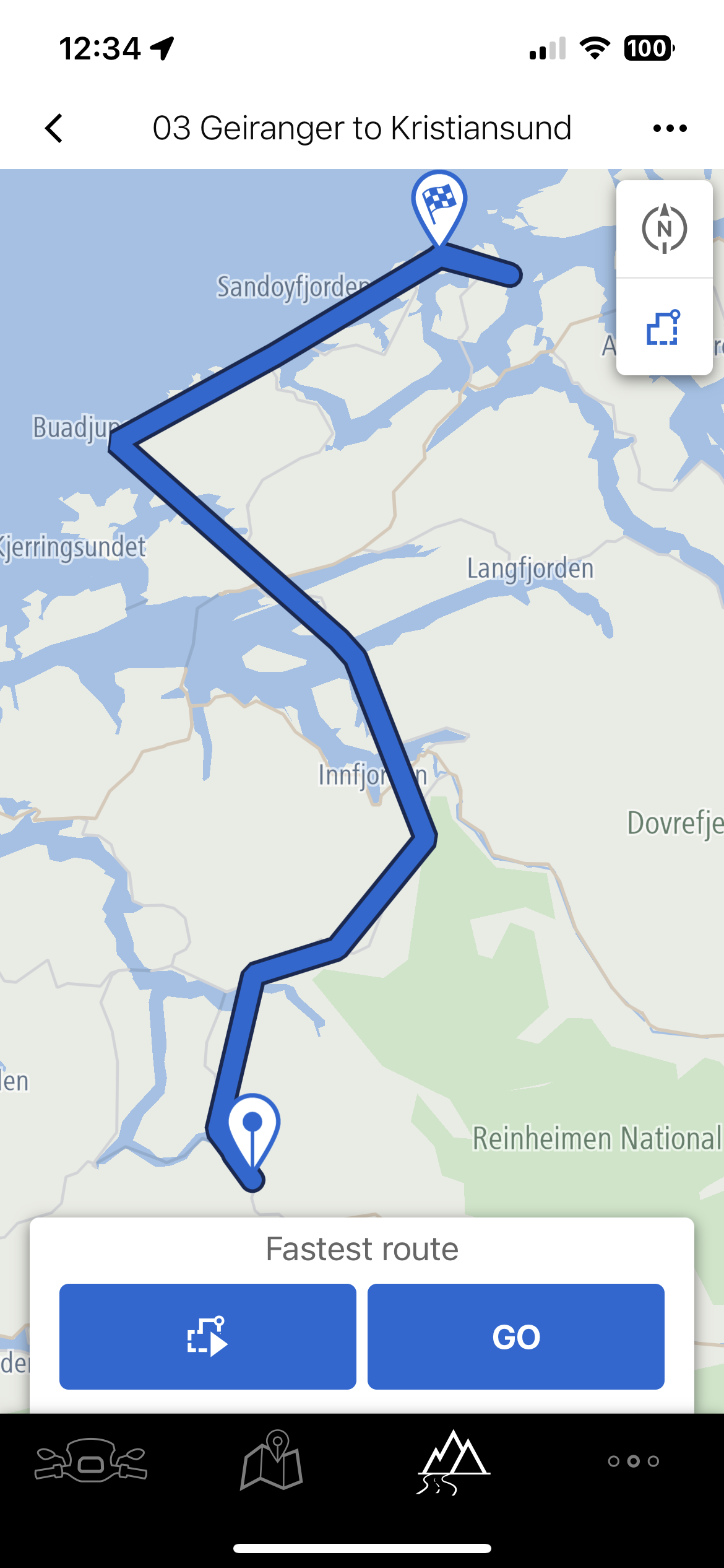
When you bring that in it will look like it has 'direct lines' (which it does, point-to-point). See below:
Now press the button to the left of 'Go' (with the 'play' like symbol). This will offer you a sub-menu of how you want the route plotted. Select 'From start point'. (see below)
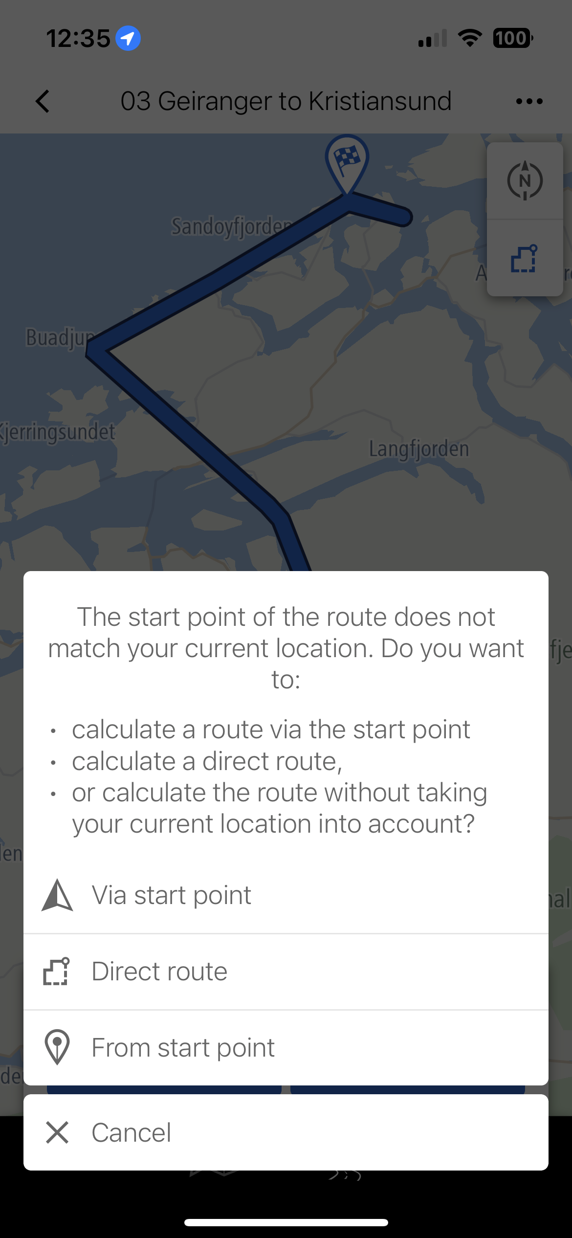
This will plot your route honouring the 'support points' you entered. (see below)
It would be great if BMW offered an online 'viewer' as it's then tough on the phone, but try and check the route has in fact plotted as you think. It should as Tom-Tom, should match Tom-Tom.
The TFT does now give you the option to skip-waypoints and if not you just automatically fire through. Any Via Points on the route will of course 'announce', so I often add Via Points called 'One Hundred Kilometre Marker' for example.
I started this with LIMITED so bear that in mind, but I have a test Normandy trip upcoming on 29th and then a month from UK to Nordkapp and back via Finland, et al.
As Alex also says, with the app if you're bored you can see bike telemetrics, such as see how far you lent left and right, top speed, when and where you triggered ABS or traction control and such. It also stores any photos along the route.
If you select the 'track' option on import, you will get no announcements but 1,000s of 'shaping points' that will ensure you don't deviate from the route. That is another option we've used before and it certainly works.
Hope this helps?
-
@Mike-Denning I am a long complainer about the connected app and it's implementation on the 6.5in TFT as fitted to the GS and GSA (I've had one of each). Over time it has got better but was never quite there.
I now have the K1600GT (with 10.25 TFT and map-view of course) and had everything updated a few weeks ago (TFT and app) and I would say the connected app is now 90% there.
Here's my LIMITED experience with the two... (Gold membership will be necessary for all functions)
The key I find is to plot a route using Tom-Tom maps (as this is the system the Connected App uses) with 'just' enough Waypoints or Via Points to ensure your route cannot deviate. (Place a waypoint just after a junction for example to ensure the route will go that way). MRA does have a function to add waypoints automatically, but I find that it adds too many, so I either use the 'reduce waypoint' function (where you can then choose how many you want), or just do it yourself. If you use an automated way check they are a) on the actual road, b) placed logically.
Export the file as GPX 1.1 (Route, Track, POI). When importing into the Connected App this will offer you the three parts (Route, Track, POI), deselect for now the Track and POI ones, leaving just the route one. This will have x number of 'support points' that matches the Via and Waypoints in your MRA export.
When you bring that in it will look like it has 'direct lines' (which it does, point-to-point). See below:
Now press the button to the left of 'Go' (with the 'play' like symbol). This will offer you a sub-menu of how you want the route plotted. Select 'From start point'. (see below)
This will plot your route honouring the 'support points' you entered. (see below)
It would be great if BMW offered an online 'viewer' as it's then tough on the phone, but try and check the route has in fact plotted as you think. It should as Tom-Tom, should match Tom-Tom.
The TFT does now give you the option to skip-waypoints and if not you just automatically fire through. Any Via Points on the route will of course 'announce', so I often add Via Points called 'One Hundred Kilometre Marker' for example.
I started this with LIMITED so bear that in mind, but I have a test Normandy trip upcoming on 29th and then a month from UK to Nordkapp and back via Finland, et al.
As Alex also says, with the app if you're bored you can see bike telemetrics, such as see how far you lent left and right, top speed, when and where you triggered ABS or traction control and such. It also stores any photos along the route.
If you select the 'track' option on import, you will get no announcements but 1,000s of 'shaping points' that will ensure you don't deviate from the route. That is another option we've used before and it certainly works.
Hope this helps?
@Nick-Hodge
Thank you for this clear instruction!")
Up till now I used the option with a large amount of "supporting points" (created by the Connected App). Your way of working makes more sense for me.BMW "Blakkietrie" R1250RT (2023)
Mazda "Max" MX5 ND (2016) -
@Nick-Hodge
Thank you for this clear instruction!
Up till now I used the option with a large amount of "supporting points" (created by the Connected App). Your way of working makes more sense for me.@Alex-Van-Vlerken you could import both at the same time (by checking ‘route’ and ‘track’ during the import), then you have both!!


-
I have a 2023 R 1250 RT, and a long time user of MRA. I export my MRA routes to my Harley Boom Box and it works great up to 100 waypoints. I am having a difficult time figuring out the Connect app. Can I work around the 50 waypoint limit of the Connect app by importing the track instead of the route, confident that the several hundred points being transferred will keep me on the same roads as if I imported the route and converted it to waypoints?
@Sam-Kramer
The BMW Connected App can import tracks.
Of course you will not see any waypoints.
But it does have the advantage that the route in the Connected App is (almost) entirely the same as the planned route in MRA. Make your route in MRA or with the TomTom map. -
@Sam-Kramer
The BMW Connected App can import tracks.
Of course you will not see any waypoints.
But it does have the advantage that the route in the Connected App is (almost) entirely the same as the planned route in MRA. Make your route in MRA or with the TomTom map.@Jack-van-Tilburg I must have a misunderstanding of what a track is.
If I want to go from A to B, say 100 miles apart, and I want to take numerous quiet country roads that no GPS would choose because it adds many unnecessary but desired roads, the only way I know how to create my desired path is to “nail” down each turn with a waypoint.
My understanding of a track is have my GPS “track” the route I am actually riding so I can repeat it again. How can I “load” a track into my GPS if I haven’t rode it first?
-
@Jack-van-Tilburg I must have a misunderstanding of what a track is.
If I want to go from A to B, say 100 miles apart, and I want to take numerous quiet country roads that no GPS would choose because it adds many unnecessary but desired roads, the only way I know how to create my desired path is to “nail” down each turn with a waypoint.
My understanding of a track is have my GPS “track” the route I am actually riding so I can repeat it again. How can I “load” a track into my GPS if I haven’t rode it first?
@Sam-Kramer
Once you have created a route in MRA Planner, you can save it in various ways.
One of them is 'Save as' gpx 1.1 (track, POI).
You can import that file into your Connected App.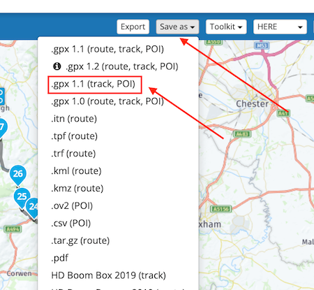
I don't know if you also have sufficient knowledge of how to do this in the connected app.
Hello! It looks like you're interested in this conversation, but you don't have an account yet.
Getting fed up of having to scroll through the same posts each visit? When you register for an account, you'll always come back to exactly where you were before, and choose to be notified of new replies (either via email, or push notification). You'll also be able to save bookmarks and upvote posts to show your appreciation to other community members.
With your input, this post could be even better 💗
Register Login-
012396
-
0437
-
2430
-
0360
-
0231
-
210135
-
06536.4k
-
43179